Perla, Arkansas
| Perla, Arkansas | |
|---|---|
| Town | |
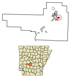 Location of Perla in Hot Spring County, Arkansas. | |
| Coordinates: 34°21′52″N 92°46′44″W / 34.36444°N 92.77889°WCoordinates: 34°21′52″N 92°46′44″W / 34.36444°N 92.77889°W | |
| Country | United States |
| State | Arkansas |
| County | Hot Spring |
| Area[1] | |
| • Total | 0.96 sq mi (2.48 km2) |
| • Land | 0.96 sq mi (2.48 km2) |
| • Water | 0.00 sq mi (0.00 km2) |
| Elevation | 335 ft (102 m) |
| Population (2010) | |
| • Total | 241 |
| • Estimate (2017)[2] | 244 |
| • Density | 254.43/sq mi (98.22/km2) |
| Time zone | UTC-6 (Central (CST)) |
| • Summer (DST) | UTC-5 (CDT) |
| ZIP code | 72104 |
| Area code(s) | 501 |
| FIPS code | 05-54620 |
| GNIS feature ID | 0053285 |
Perla is a town in Hot Spring County, Arkansas, United States. The population was 241 at the 2010 census,[3] up from 115 at the 2000 census.
Geography
Perla is located in northeastern Hot Spring County at 34°21′52″N 92°46′44″W / 34.36444°N 92.77889°W (34.364535, -92.778771).[4] It is bordered to the west by the city of Malvern, the Hot Spring County seat. U.S. Route 67 runs through the center of Perla, leading west into Malvern and northeast 20 miles (32 km) to Benton. U.S. Route 270 passes through the eastern end of Perla, leading east 22 miles (35 km) to Sheridan and northwest 4 miles (6 km) to Interstate 30.
According to the United States Census Bureau, Perla has a total area of 0.93 square miles (2.4 km2), all land.[3]
Demographics
| Historical population | |||
|---|---|---|---|
| Census | Pop. | %± | |
| 1970 | 227 | — | |
| 1980 | 149 | −34.4% | |
| 1990 | 145 | −2.7% | |
| 2000 | 115 | −20.7% | |
| 2010 | 241 | 109.6% | |
| Est. 2017 | 244 | [2] | 1.2% |
| U.S. Decennial Census[5] | |||
As of the census[6] of 2000, there were 115 people, 56 households, and 30 families residing in the town. The population density was 69.4/km² (180.0/mi²). There were 67 housing units at an average density of 40.4/km² (104.9/mi²). The racial makeup of the town was 36.52% White and 63.48% Black or African American.
There were 56 households out of which 16.1% had children under the age of 18 living with them, 33.9% were married couples living together, 16.1% had a female householder with no husband present, and 46.4% were non-families. 42.9% of all households were made up of individuals and 16.1% had someone living alone who was 65 years of age or older. The average household size was 2.05 and the average family size was 2.87.
In the town, the population was spread out with 18.3% under the age of 18, 14.8% from 18 to 24, 24.3% from 25 to 44, 21.7% from 45 to 64, and 20.9% who were 65 years of age or older. The median age was 41 years. For every 100 females, there were 88.5 males. For every 100 females age 18 and over, there were 91.8 males.
The median income for a household in the town was $19,545, and the median income for a family was $25,625. Males had a median income of $21,250 versus $16,250 for females. The per capita income for the town was $14,676. There were 20.0% of families and 22.9% of the population living below the poverty line, including 33.3% of under eighteens and 32.0% of those over 64.
References
- ↑ "2017 U.S. Gazetteer Files". United States Census Bureau. Retrieved Aug 22, 2018.
- 1 2 "Population and Housing Unit Estimates". Retrieved March 24, 2018.
- 1 2 "Geographic Identifiers: 2010 Demographic Profile Data (G001): Perla town, Arkansas". American Factfinder. U.S. Census Bureau. Retrieved April 21, 2017.
- ↑ "US Gazetteer files: 2010, 2000, and 1990". United States Census Bureau. 2011-02-12. Retrieved 2011-04-23.
- ↑ "Census of Population and Housing". Census.gov. Retrieved June 4, 2015.
- ↑ "American FactFinder". United States Census Bureau. Retrieved 2008-01-31.
Municipalities and communities of Hot Spring County, Arkansas, United States | ||
|---|---|---|
| Cities | 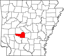 | |
| Towns | ||
| Census-designated place | ||
| Unincorporated communities |
| |
| Townships |
| |
| Ghost towns |
| |