Pergamos, Cyprus
| Pergamos | |
|---|---|
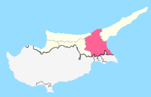
 Pergamos Location in Cyprus | |
| Coordinates: 35°2′34″N 33°42′25″E / 35.04278°N 33.70694°ECoordinates: 35°2′34″N 33°42′25″E / 35.04278°N 33.70694°E | |
| Country |
|
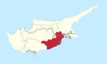
| • District | Larnaca District |
| Country (controlled by) |
|
| • District | Gazimağusa District |
| Government | |
| • Mayor | İlker Edip |
| Population (2011)[1] | |
| • Total | 1,196 |
| • Municipality | 4,125 |
| Time zone | UTC+2 (EET) |
| • Summer (DST) | UTC+3 (EEST) |
| Website | Turkish Cypriot municipality |
Pergamos (Greek: Πέργαμoς; Turkish: Beyarmudu) is a Turkish Cypriot village in Larnaca District, Cyprus, 4 km north of Pyla, almost surrounded by the British Sovereign Base Area (SBA) at Dhekelia. [2]
Under Ottoman rule it was in the Caza of Famagusta and initially remained so under British rule.[3] Around 1920 it was moved to Larnaca District.[4][5]
Name
The origin of the name is uncertain and may be associated with ancient Pergamon in Asia Minor. The Turkish Cypriot name became Beyarmudu in 1958, meaning lord's pear.[2] Pergamos was actually called Pergama and is visible on a map which was published by Jacomo Franco in Venice 1570.
Demographics
Pergamos had a population of 87 in 1881 (first British census).[3] During the British period it was almost solely inhabited by Turkish Cypriots, which it remains.[2] In 1960 there were 826 inhabitants, all Turkish Cypriots.[6] In 2011 the population was 1,196, a slight decrease from 1,270 in 2006.[1] Some Turkish Cypriots who were displaced to Pergamos during the 1960s have remained since in the village.[2]
Current conditions
Apart from the area within the SBA, it lies within the Turkish sector under the De facto control of Northern Cyprus, in the new Famagusta district of the Turkish Cypriots.[2]
Pergamos is the site of a Green Line crossing checkpoint. That and the proximity of the SBA has assisted economic development in the area.[2]
International relations
Twin towns – sister cities
Pergamos is twinned with:
References
- 1 2 KKTC 2011 Nüfus ve Konut Sayımı [TRNC 2011 Population and Housing Census] (PDF), TRNC State Planning Organization, 6 August 2013, p. 19
- 1 2 3 4 5 6 PRIO web site http://www.prio-cyprus-displacement.net/default.asp?id=383 retrieved Aug 2018
- 1 2 Census of Cyprus 1881, printed by Eyre & Spottiswoode, London , 1884
- ↑ Report and General Abstracts of the Census of Cyprus 1911, publ. Waterlow and Sons Ltd, London, 1912
- ↑ Report and General Abstracts of the Census of Cyprus 1921, publ. Waterlow and Sons Ltd, London, 1922
- ↑ Census of Population and Agriculture 1960, pub.Printing Office of the Republic of Cyprus, Nicosia, 1960; Vol.1, Table IV
- ↑ Sarıyer - Twin Towns, Sarıyer-City.sk, retrieved 2013-10-19
- ↑ Kepez - Twin Towns, Kepez-City.sk, archived from the original on 2013-10-19, retrieved 2013-10-19
- ↑ Karaman - Twin Towns, Karaman-City.sk, retrieved 2013-10-19
| Lefkoşa District | |
|---|---|
| Gazimağusa District | |
| Girne District | |
| Güzelyurt District | |
| İskele District | |
| Lefke District | |