Payneway, Arkansas
| Payneway, Arkansas | |
|---|---|
| Unincorporated community | |
 Payneway, Arkansas Payneway's position in Arkansas. | |
| Coordinates: 35°32′35″N 90°30′10″W / 35.54306°N 90.50278°WCoordinates: 35°32′35″N 90°30′10″W / 35.54306°N 90.50278°W | |
| Country |
|
| State |
|
| County | Poinsett |
| Township | Little River |
| Elevation[1] | 65 m (213 ft) |
| Time zone | UTC-6 (Central (CST)) |
| • Summer (DST) | UTC-5 (CDT) |
| Area code(s) | 870 |
| GNIS feature ID | 57894 |
| U.S. Geological Survey Geographic Names Information System: Payneway, Arkansas | |
Payneway (formerly Harrisburg Corner) is an unincorporated community in Little River Township, Poinsett County, Arkansas, United States.[2] It is located west of Marked Tree near the intersection of Arkansas Highway 463 (formerly U.S. Route 63) and Arkansas Highway 14.[3]
References
- ↑ "Payneway, Arkansas." Histopolis Retrieved July 18, 2011.
- ↑ "Feature Detail Report for: Payneway, Arkansas". United States Geological Survey. Retrieved July 18, 2011.
- ↑ Arkansas Atlas and Gazetteer (Map) (Second ed.). DeLorme. § 37.
Municipalities and communities of Poinsett County, Arkansas, United States | ||
|---|---|---|
| Cities | 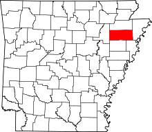 | |
| Town | ||
| Unincorporated communities | ||
This article is issued from
Wikipedia.
The text is licensed under Creative Commons - Attribution - Sharealike.
Additional terms may apply for the media files.