Mount Olive, Poinsett County, Arkansas
| Mount Olive, Arkansas | |
|---|---|
| Unincorporated community | |
 Mount Olive, Arkansas  Mount Olive, Arkansas | |
| Coordinates: 35°28′57″N 90°24′46″W / 35.48250°N 90.41278°WCoordinates: 35°28′57″N 90°24′46″W / 35.48250°N 90.41278°W | |
| Country | United States |
| State | Arkansas |
| County | Poinsett |
| Elevation | 217 ft (66 m) |
| Time zone | UTC-6 (Central (CST)) |
| • Summer (DST) | UTC-5 (CDT) |
| Area code(s) | 870 |
| GNIS feature ID | 57130[1] |
Mount Olive is an unincorporated community in Poinsett County, Arkansas, United States. Mount Olive is located at the junction of Arkansas Highway 149 and Arkansas Highway 322, 3.5 miles (5.6 km) south of Marked Tree.[2]
References
- ↑ "Mount Olive". Geographic Names Information System. United States Geological Survey.
- ↑ Poinsett County, Arkansas General Highway Map (PDF) (Map). Arkansas State Highway and Transportation Department. 2009. Retrieved September 18, 2012.
Municipalities and communities of Poinsett County, Arkansas, United States | ||
|---|---|---|
| Cities | 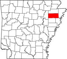 | |
| Town | ||
| Unincorporated communities | ||
This article is issued from
Wikipedia.
The text is licensed under Creative Commons - Attribution - Sharealike.
Additional terms may apply for the media files.