Paxson, Virginia
| Paxson, Virginia | |
|---|---|
| Unincorporated community | |
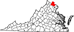
 Paxson, Virginia Location within the Commonwealth of Virginia  Paxson, Virginia Paxson, Virginia (Virginia)  Paxson, Virginia Paxson, Virginia (the US) | |
| Coordinates: 39°5′45″N 77°48′27″W / 39.09583°N 77.80750°WCoordinates: 39°5′45″N 77°48′27″W / 39.09583°N 77.80750°W | |
| Country |
|
| State |
|
| County |
|
| Time zone | UTC−5 (Eastern (EST)) |
| • Summer (DST) | UTC−4 (EDT) |
Paxson is an unincorporated community in Loudoun County, Virginia. Paxson lies south of Round Hill at the crossroads of Snickersville Turnpike (Virginia Secondary Route 734) and Yellow Schoolhouse Road.
This article is issued from
Wikipedia.
The text is licensed under Creative Commons - Attribution - Sharealike.
Additional terms may apply for the media files.