Bloomfield, Virginia
| Bloomfield, Virginia | |
|---|---|
| Unincorporated community | |
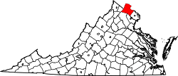
 Bloomfield, Virginia Location within the Commonwealth of Virginia  Bloomfield, Virginia Bloomfield, Virginia (Virginia)  Bloomfield, Virginia Bloomfield, Virginia (the US) | |
| Coordinates: 39°3′12″N 77°49′14″W / 39.05333°N 77.82056°WCoordinates: 39°3′12″N 77°49′14″W / 39.05333°N 77.82056°W | |
| Country |
|
| State |
|
| County |
|
| Elevation | 535 ft (163 m) |
| Time zone | UTC−5 (Eastern (EST)) |
| • Summer (DST) | UTC−4 (EDT) |
| GNIS feature ID | 1492591[1] |
Bloomfield is an unincorporated community in Loudoun County, Virginia.[1] It is situated at the intersection of Airmont (VA 719) and Bloomfield (VA 626) Roads.
The town of Bloomfield was founded by the Virginia General Assembly on January 13, 1816. The town was named for fields of wildflowers along the Blue Ridge near the town. During the Civil War, Confederate forces under Maj. Gen J.E.B. Stuart biouvacked in Bloomfield during the Battle of Unison. Later in the war Col. Mosby and his Rangers visited the town to divide up $173,000 they had robbed from a Union payroll train in West Virginia during the Greenback Raid.
The Ebenezer Baptist Churches were listed on the National Register of Historic Places in 1994.[2]
References
- 1 2 "Bloomfield". Geographic Names Information System. United States Geological Survey.
- ↑ National Park Service (2010-07-09). "National Register Information System". National Register of Historic Places. National Park Service.
This article is issued from
Wikipedia.
The text is licensed under Creative Commons - Attribution - Sharealike.
Additional terms may apply for the media files.