Pano Archimandrita
| Pano Archimandrita | |
|---|---|
 | |
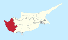
 Pano Archimandrita Location in Cyprus | |
| Coordinates: 34°45′3″N 32°40′39″E / 34.75083°N 32.67750°ECoordinates: 34°45′3″N 32°40′39″E / 34.75083°N 32.67750°E | |
| Country |
|
| District | Paphos District |
| Population (2001)[1] | |
| • Total | 42 |
| Time zone | UTC+2 (EET) |
| • Summer (DST) | UTC+3 (EEST) |
| Postal code | 6200 |
Pano Archimandrita (Greek: Πάνω Αρχιμανδρίτα) is a village in the Paphos District of Cyprus, located 12 km northeast of Kouklia.
References
This article is issued from
Wikipedia.
The text is licensed under Creative Commons - Attribution - Sharealike.
Additional terms may apply for the media files.