Koili
| Koili Κοίλη Kili | |
|---|---|
 Koili Location in Cyprus | |
| Coordinates: 34°51′36″N 32°27′18″E / 34.86000°N 32.45500°ECoordinates: 34°51′36″N 32°27′18″E / 34.86000°N 32.45500°E | |
| Country |
|
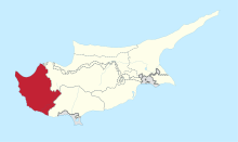
| District | Paphos District |
| Elevation | 2,070 ft (630 m) |
| Population (2011)[1] | |
| • Total | 466 |
| Time zone | UTC+2 (EET) |
| • Summer (DST) | UTC+3 (EEST) |
| Postal code | 6121 |
Koili (Greek: Κοίλη) is a village in the Paphos District of Cyprus, located 2 kilometres (1.2 mi) northwest of Tsadha.
Koili has an Altitude of 600 metres above sea level.
Koili has a population of approximately 450 with about 25 non-Cypriot families living there. It is situated 9 km from Paphos and 33 km from Polis.
With its hilltop vantage point, there are views of Paphos and the surrounding hills. As it is a small village there is only one restaurant, which is rarely open, no supermarket, no kiosks and two coffee shops. The nearest police station and hospital are both in Paphos.
The majority of the local houses and churches in Koili are made with local stone. The old church of Agios Mamas in Koili was ruined by a massive earthquake in 1955 and is now covered by a trimithia tree. Before the earthquake, the whole village and the locals of the surrounding villages would visit Agios Mamas to celebrate the end of Easter, and also celebrate the end of their fasting.
The church in the village square, Panagia Chryseleousis, replaced an older church which had stood in the same spot since the late 15th/early 16th century. It was completely rebuilt using stone from the local quarry, which is now disused.[2]