Pacific Northwest Trail
| Pacific Northwest Trail | |
|---|---|
 The Pacific Northwest Trail | |
| Length | 1200 mi (1931 km) |
| Location | Montana / Idaho / Washington, United States |
| Designation | National Scenic Trail in 2009 |
| Trailheads |
Glacier National Park, MT Cape Alava, WA |
| Use |
Hiking Mountain biking Equestrian |
| Elevation | |
| Highest point | Cathedral Pass, Washington |
| Lowest point | Pacific Ocean |
| Hiking details | |
| Season | Year-round at lower elevations, summer and fall at higher elevations |
| Sights |
Rocky Mountains Mount Baker Pacific Ocean |
| Hazards |
Severe weather Steep grades Navigation Swift Fords Grizzly bears Black bears Mountain Lions Moose Rattlesnakes |
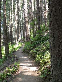
The Pacific Northwest Trail (PNT) is a 1200-mile hiking trail running from the Continental Divide in Montana to the Pacific Ocean on Washington’s Olympic Coast. Along the way, the PNT crosses three national parks, seven national forests, two other national scenic trails, and against the grain of several mountain ranges, including the Continental Divide, Whitefish Divide, Purcells, Selkirks, Kettles, Cascades, and Olympics. The Pacific Northwest Trail was designated as the Pacific Northwest National Scenic Trail by Congress in 2009.
History
The route was first conceived by Ron Strickland in 1970. Between 1970 and 1976, extensive fieldwork was performed by Strickland and others, including early supporters along the PNT corridor who lent extensive knowledge of local trail systems to the effort. In that time, the Pacific Northwest Trail was cobbled together using preexisting trails and Forest Service roads.[1]
In 1977, Strickland founded the Pacific Northwest Trail Association (PNTA), an organization responsible for education and information, maintenance, and advocacy for the PNT.[2] That same year, the first five successful thru-hikes of the Pacific Northwest Trail were completed. Two of those hikers would later appear on the cover of Backpacker Magazine, in a 1979 issue which introduced the Pacific Northwest Trail to an international audience.[3] Also in 1979, the first short guide for the PNT was published by Signpost Magazine, which would later become Washington Trails Association. The guide consisted of two pages that described the route, and came unaccompanied by maps.
In 1983, Ron Strickland would hike the entire length of the PNT alongside the PNTA’s first cartographer, Ted Hitzroth. They used the information collected on their journey to develop the first full-length guidebook for the PNT, which was published in 1984.[4]
Throughout the 80’s and 90’s, the trail gained in popularity. Regional volunteer groups emerged to help the PNTA maintain and improve the PNT in their areas, including SWITMO (Skagit Whatcom Island Trail Maintenance Organization) in the Puget Sound area,[5] and the Yaak Trail Club, who helped select and maintain the route through northwest Montana’s Yaak Valley.[6]
In 2000, the Pacific Northwest Trail received its first federal designation, when the Clinton administration designated the trail as a Millennium Trail. More federal recognition would come in the following years. In 2002, the North Cascades National Park / Ross Lake National Recreation Area segment was designated a National Recreation Trail.[7] The Olympic National Park segment received this designation in 2003,[8] and the Glacier National Park segment received the same designation in 2005.[9]
In 2008, Congressman Norm Dicks and Senator Maria Cantwell introduced Pacific Northwest National Scenic Trail legislation to Congress. The marked up version of the legislation for the designation passed the full Natural Resource Committee of the US Senate on September 11, 2008, and was then inserted into the Public Lands Omnibus Bill. Congress passed the Omnibus Public Lands Management Act of 2009 on March 25 of that year, and the Pacific Northwest Trail became the Pacific Northwest National Scenic Trail with President Obama’s signature on March 30.[10]
The Public Lands Omnibus Act of 2009 placed the trail under the management of the Department of Agriculture, with the United States Forest Service serving as the trail administrator. A comprehensive management plan for the Pacific Northwest Trail is currently under development.[11]
In 2017, the Pacific Northwest Trail Association celebrated its 40th anniversary, as well as the 40th anniversary of the first five thru-hikes of the trail.
Description of the route
Beginning at Chief Mountain Customs on the United States–Canada border in central Montana, the Pacific Northwest Trail traverses the high mountains and valleys of Glacier National Park, where it shares mileage with the Continental Divide Trail. Then it enters Flathead National Forest, travels across the Flathead River into Polebridge, Montana, up the Whitefish Divide, into Kootenai National Forest, and through the Ten Lakes Wilderness Study Area and Ten Lakes Scenic Area on its way to the Idaho state line.
In Idaho Panhandle National Forest, the PNT crosses the Moyie River Valley, winds its way through the forest lands, dikes, and farmlands of the Kootenai River Valley, up Parker Ridge to the Selkirk Crest, then down Lions Head and over Lookout Mountain to Upper Priest Lake. From there, the trail climbs toward the Washington state line.
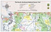
In Washington, the PNT enters Colville National Forest in the Salmo-Priest Wilderness, then crosses the Pend Oreille River on the Metaline Falls Bridge, before continuing over Abercrombie Mountain and reaching the Columbia River, in the town of Northport.
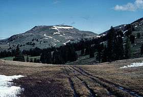
Next, the trail wanders along the Kettle Crest, through Okanogan-Wenatchee National Forest and into the range lands and orchards of the Okanogan River Valley. From the city of Oroville, Washington, the PNT follows the Similkameen River to Palmer Lake, where the trail travels through Loomis State Forest, and then begins its ascent into the Pasayten Wilderness, where the PNT shares tread with the Pacific Crest Trail.
After traversing the Pasayten, the trail crosses Ross Lake National Recreation Area and North Cascades National Park. The trail exits the park via Hannegan Pass, and continues through the Mt. Baker Wilderness. From Mount Baker-Snoqualmie National Forest, the trail uses a mix of federal, state, and private timber lands to reach the shores of Puget Sound.
Along the dikes and through the farmlands of Skagit County, the trail traverses Fidalgo Island, crosses the bridge at Deception Pass State Park and continues across Whidbey Island to the Washington State Ferry Terminal in Coupeville, Washington.
After a thirty-minute ferry ride, the trail picks up in the quaint seaside community of Port Townsend, Washington and the confluence of three trails: the Larry Scott Trail, the Olympic Discovery Trail, and the Pacific Northwest Trail. The trails circumnavigate the northeastern tip of the Olympic Peninsula and Discovery Bay before going their separate directions, with the PNT turning southwest through Olympic National Forest, Buckhorn Wilderness and into Olympic National Park.
As the trail leaves the park and travels along the Bogachiel River it finds its way through the northern end of the Hoh Rain Forest to the Pacific Ocean at the mouth of the Hoh River. There, the trail turns north and wanders along the Wilderness Coast where it enters the Quileute Indian Reservation near the town of La Push, then continues north to its western terminus at Cape Alava.
Protected areas through which the PNT passes
- Glacier National Park
- Flathead National Forest
- Kootenai National Forest
- Idaho Panhandle National Forest
- Colville National Forest
- Okanogan National Forest
- North Cascades National Park
- Mt. Baker-Snoqualmie National Forest
- Deception Pass State Park
- Bay View State Park
- Joseph Whidbey State Park
- Fort Ebey State Park
- Ebey's Landing National Historical Reserve
- Fort Casey State Park
- Olympic National Forest
- Olympic National Park
See also
- Connected National Scenic Trails
- Continental Divide Trail - Shares a common start/end point with the PNT in Glacier National Park.
- Pacific Crest Trail - Shares mileage in the Pasayten Wilderness.
- Connected U.S. long-distance trails
References
- ↑ https://www.amazon.com/Pathfinder-Blazing-Wilderness-Modern-America/dp/0870716034 Amazon.com: Pathfinder: Blazing a New Wilderness Trail in Modern America
- ↑ http://pnt.org/who-we-are/mission/
- ↑ https://books.google.com/books?id=buADAAAAMBAJ&printsec=frontcover&rview=1&lr=#v=onepage&q&f=false Backpacker Magazine #34
- ↑ https://www.amazon.com/Pacific-Northwest-Trail-Guide-Collection/dp/0916076628 Pacific Northwest Trail Guide
- ↑ http://www.switmo.org/about.shtml SWITMO.org
- ↑ https://www.pnt.org/1999yaak2/ Nor'Wester Magazine, February 1999
- ↑ http://www.americantrails.org/NRTDatabase/trailDetail.php?recordID=3317 Pacific Northwest Trail - North Cascades National Park/Ross Lake NRA Segment
- ↑ http://www.americantrails.org/NRTDatabase/trailDetail.php?recordID=3383 Pacific Northwest Trail - Olympic National Park Segment
- ↑ http://www.americantrails.org/NRTDatabase/trailDetail.php?recordID=3437 Pacific Northwest Trail - Glacier National Park Segment
- ↑ https://www.nytimes.com/2009/03/30/us/politics/30lands-text.html?_r=1 New York Times, Obama Signs the Omnibus Public Lands Management Act of 2009
- ↑ https://www.fs.usda.gov/main/pnt/land-resources-management/planning Forest Service PNNST Comprehensive Plan website
External links
| Wikimedia Commons has media related to Pacific Northwest Trail. |
- Forest Service website
- Pacific Northwest Trail Association
- Amazon.com : Pacific Northwest Trail Guide: The Official Guidebook for Long Distance and Day Hikers
- Amazon.com : Pacific Northwest Trail Town Guide
- Amazon.com : Pacific Northwest Trail Digest: Trail Tips and Navigation Notes
- A Thru Hikers Trail Journal
- The Pacific Northwest Trail description on Summit Post
- Amazon.com: Pathfinder: Blazing a New Wilderness Trail in Modern America
- Pacific Northwest National Scenic Trail - BLM page