Metaline Falls Bridge
| Metaline Falls Bridge | |
|---|---|
.jpg) Metaline Falls Bridge | |
| Coordinates | 48°51′41″N 177°22′15″W / 48.86139°N 177.37083°WCoordinates: 48°51′41″N 177°22′15″W / 48.86139°N 177.37083°W |
| Carries |
|
| Crosses | Pend Oreille River |
| Locale | Metaline Falls, Washington |
| Maintained by | Washington State Department of Transportation |
| Characteristics | |
| Design | Warren deck truss |
| Total length | 696 feet (212 m) |
| Width | 26 feet (8 m) |
| Longest span | 240 feet (73 m) |
| Clearance below | 20 feet (6 m) |
| History | |
| Opened | 1952 |
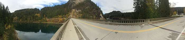
The Metaline Falls Bridge carries Washington State Route 31 over the Pend Oreille River in the extreme northeast corner of the state. Officially the Pend Oreille Bridge, it provides access from the south to the town of Metaline Falls and the Boundary Dam. Completed in 1952, the bridge is a 696 feet (212 m) long and 26 feet (7.9 m) wide combination steel truss and concrete T-beam structure. Consisting of three main Warren deck truss spans, the longest of which is 240 feet (73 m), the bridge carries two lanes of traffic and a pedestrian walkway.[1]
Eligible to be placed on the National Register of Historic Places, WSDOT currently classifies the bridge as Functionally Obsolete,[2] a term no longer recognized for Federal Highway Fund purposes. The Federal Highway Administration evaluates bridges listed in the National Bridge Inventory using a nine tier scale, and effective in 2018, any bridge getting a grade of "Poor" or worse in any category was deemed Structurally Deficient.[3] The Metaline Falls Bridge lowest grade was "Fair" for its superstructure condition.[4]

The bridge is a key part of the Pacific Northwest Trail and the International Selkirk Loop, both of which attract many outdoor enthusiasts to the Metaline Falls area. Washington Rock, a favorite climbing venue in the region, is almost directly above the point where SR 31 turns southeast to enter the town which allows climbers to take almost vertical photos of the bridge.[5]
References
- ↑ "Metaline Falls Bridge". Bridgehunter.com. Retrieved 2018-09-19.
- ↑ "Historic Highway Bridges" (PDF). wsdot.wa.gov. Retrieved 2018-10-10.
- ↑ "National Bridge Inventory Inspection Rating System". fhwa.dot.gov. Retrieved 2018-10-12.
- ↑ "National Bridge Inventory Evaluation (2017)". fhwa.dot.gov. Retrieved 2018-10-12.
- ↑ "Metaline Falls Rock Climbing". MountainProject.com. Retrieved 2018-09-19.