Overshooting top

An overshooting top (or penetrating top) is a dome-like protrusion shooting out of the top of the anvil of a thunderstorm. When an overshooting top is present for 10 minutes or longer, it's a strong indication the storm is severe.[1]
Formation

When a thunderstorm forms, clouds build vertically into the atmosphere until the storm's updraft (warm rising air) has reached an equilibrium level (EL); the point where the surrounding air is about the same temperature or even warmer.[2] This point of equilibrium is often marked by the tropopause. Rather than continuing to rise into the stratosphere, the vertical cloud growth abruptly stops, and instead clouds spread horizontally, forming an "anvil" shape on top of the thunderstorm.[1]
An overshooting top forms when a thunderstorm's updraft, due to momentum from rapid ascent and strength of lifting, protrudes its equilibrium level, forming a dome-like structure on top of the anvil.[3] This can occur with any cumulonimbus cloud when instability is high. Whereas anvils form at the equilibrium level, overshooting tops continue to the maximum parcel level (MPL).
Severe weather
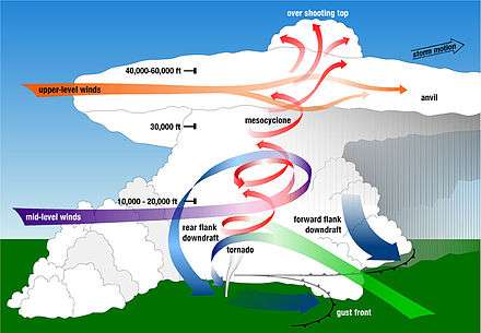
Most thunderstorms will have an overshooting top at some point in their life cycle.[2] In weaker thunderstorms, the overshooting top is short-lived, and often takes on a wispy appearance.[3] If the overshooting top is rising and falling in a cyclical fashion, then it could indicate the storm is pulsing and not as strong as a storm with a continuous overshooting top.[4]
An overshooting top lasting for more than 10 minutes is a sign of a strong updraft in a thunderstorm, indicating a strong likelihood the storm is producing severe weather.[2] If the overshooting top is continuous, it's an indication of enhanced probability that the storm is a supercell.[3] During a strong tornado, the overshooting top may roll or fold over as new activity climbs up the back while the front of the overshooting top collapses into the storm. During a long-track tornado, the entire top of the storm, including the overshooting top, may drop by thousands of feet.
Precipitation
A storm powerful enough to produce a lasting overshooting top will have the following:
- Heavy rain; a deluge of rain could fall from this storm in a short amount of time.
- Strong wind; the storm clouds have powerful winds churning inside them. These winds are likely to be felt at the surface as well, possibly in the form of a tornado.
- Hail; if the updraft is strong enough to produce an overshooting top it can also carry large hail.
- Lightning; this is sure to be a thunderstorm.
See also
References
- 1 2 Chance Hayes, National Weather Service Wichita, Kansas. "Storm Fury on the Plains." Storm Spotter Training. 4H Building, Salina, Kansas. 22 Feb. 2010. Lecture.
- 1 2 3 "Thunderstorm Detection". National Severe Storms Lab (NSSL). Retrieved 2009-02-28.
- 1 2 3 "Overshooting Top definition". NSSL. Retrieved 2009-02-28.
- ↑ "JetStream - Glossary". National Weather Service. August 29, 2007. Retrieved 2008-02-28.