Arcus cloud
An arcus cloud is a low, horizontal cloud formation, usually appearing as an accessory cloud to a cumulonimbus. Roll clouds and shelf clouds are the two main types of arcus. Arcus clouds most frequently form along the leading edge or "gust fronts" of thunderstorm outflow; some of the most dramatic arcus formations mark the gust fronts of derecho-producing convective systems. Roll clouds also may arise in the absence of thunderstorms, forming along the shallow cold air currents of some sea breeze boundaries and cold fronts.
Types
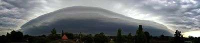
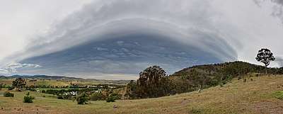
Shelf cloud

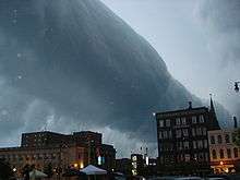
A shelf cloud is a low, horizontal, wedge-shaped arcus cloud. A shelf cloud is attached to the base of the parent cloud, which is usually a thunderstorm cumulonimbus, but could form on any type of convective clouds. Rising cloud motion often can be seen in the leading (outer) part of the shelf cloud, while the underside often appears turbulent and wind-torn. Cool, sinking air from a storm cloud's downdraft spreads out across the land surface, with the leading edge called a gust front. This outflow cuts under warm air being drawn into the storm's updraft. As the lower cooler air lifts the warm moist air, its water condenses, creating a cloud which often rolls with the different winds above and below (wind shear).
People seeing a shelf cloud may believe they have seen a wall cloud. This is likely a mistake, since an approaching shelf cloud appears to form a wall made of cloud. A shelf cloud usually appears on the leading edge of a storm, and a wall cloud will usually be at the rear of the storm.
A sharp, strong gust front will cause the lowest part of the leading edge of a shelf cloud to be ragged and lined with rising fractus clouds. In a severe case there will be vortices along the edge, with twisting masses of scud that may reach to the ground or be accompanied by rising dust. A very low shelf cloud accompanied by these signs is the best indicator that a potentially violent wind squall is approaching. An extreme example of this phenomenon looks almost like a tornado and is known as a gustnado.[1]
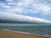
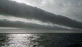
Roll cloud
A roll cloud (Cloud Atlas name volutus) is a low, horizontal, tube-shaped, and relatively rare type of arcus cloud. They differ from shelf clouds by being completely detached from other cloud features. Roll clouds usually appear to be "rolling" about a horizontal axis. They are a solitary wave called a soliton, which is a wave that has a single crest and moves without changing speed or shape. One of the most famous frequent occurrences is the Morning Glory cloud in Queensland, Australia, which can occur up to four out of ten days in October.[2] One of the main causes of the Morning Glory cloud is the mesoscale circulation associated with sea breezes that develop over the Cape York Peninsula and the Gulf of Carpentaria. However, similar features can be created by downdrafts from thunderstorms and are not exclusively associated with coastal regions.
Coastal roll clouds have been seen in many places, including California, the English Channel, Shetland Islands, the North Sea coast, coastal regions of Australia, and Nome, Alaska.
See also
- Atmospheric convection
- Horizontal convective rolls (cloud streets)
- International Cloud Atlas
- Morning Glory cloud, an extremely long variety of roll cloud
- World Meteorological Organization
References
- ↑ Meteorological Service of Canada (December 19, 2002). "Gust fronts and wind squalls". Severe Weather Watcher Handbook. Environment Canada. Archived from the original on June 23, 2006. Retrieved 2008-06-22.
- ↑ Clarke, R. H.; Smith, R. K.; Reid, D. G. (1981). "The Morning Glory of the Gulf of Carpentaria: An Atmospheric Undular Bore" (pdf). Mon. Wea. Rev. 109: 1726–1750. Bibcode:1981MWRv..109.1726C. doi:10.1175/1520-0493(1981)109<1726:TMGOTG>2.0.CO;2. Retrieved October 1, 2016.
- ↑ Sutherland, Scott (March 23, 2017). "Cloud Atlas leaps into 21st century with 12 new cloud types". The Weather Network. Pelmorex Media. Retrieved 24 March 2017.
External links
| Wikimedia Commons has media related to Roll cloud. |
| Wikimedia Commons has media related to Shelf cloud. |
| Wikimedia Commons has media related to Arcus. |
- Meteorological Service of Canada (May 14, 1999). "Spotter training : Identifying Clouds". Environment Canada. Archived from the original on July 15, 2013. Retrieved 2010-10-07.
- Roll Cloud vs. Shelf Cloud