Otsego Township, Steuben County, Indiana
| Otsego Township | |
|---|---|
| Township | |
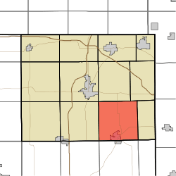 Location in Steuben County | |
| Coordinates: 41°34′13″N 84°54′40″W / 41.57028°N 84.91111°WCoordinates: 41°34′13″N 84°54′40″W / 41.57028°N 84.91111°W | |
| Country | United States |
| State | Indiana |
| County | Steuben |
| Government | |
| • Type | Indiana township |
| Area | |
| • Total | 34.78 sq mi (90.1 km2) |
| • Land | 33.54 sq mi (86.9 km2) |
| • Water | 1.24 sq mi (3.2 km2) 3.57% |
| Elevation[1] | 958 ft (292 m) |
| Population (2010) | |
| • Total | 2,575 |
| • Density | 76.8/sq mi (29.7/km2) |
| Time zone | UTC-5 (Eastern (EST)) |
| • Summer (DST) | UTC-4 (EDT) |
| Area code(s) | 260 |
| GNIS feature ID | 453697 |
Otsego Township is one of twelve townships in Steuben County, Indiana, United States. As of the 2010 census, its population was 2,575 and it contained 1,839 housing units.[2]
Geography
According to the 2010 census, the township has a total area of 34.78 square miles (90.1 km2), of which 33.54 square miles (86.9 km2) (or 96.43%) is land and 1.24 square miles (3.2 km2) (or 3.57%) is water.[2] Lakes in this township include Ball Lake, Fee Lake, Hamilton Lake, Jackson Lake, Johnson Lake and Round Lake. The stream of Black Creek runs through this township.
Cities and towns
- Hamilton (north three-quarters)
Unincorporated towns
- Circle Park at 41°32′59″N 84°54′36″W / 41.5497727°N 84.9099617°W
- Clarks Landing at 41°33′35″N 84°54′42″W / 41.5597727°N 84.9116284°W
- Cold Springs at 41°33′21″N 84°54′32″W / 41.5558838°N 84.9088505°W
- Forest Park at 41°33′02″N 84°55′31″W / 41.5506061°N 84.9252400°W
- Fountain Park at 41°33′47″N 84°54′51″W / 41.5631060°N 84.9141285°W
- Island Park at 41°32′27″N 84°55′16″W / 41.5408838°N 84.9210732°W
- Oakwood at 41°32′59″N 84°54′49″W / 41.5497727°N 84.9135729°W
- Otsego Center at 41°34′21″N 84°54′32″W / 41.5725504°N 84.9088504°W
- Penn Park at 41°32′39″N 84°55′26″W / 41.5442172°N 84.9238511°W
- Ravinia Oaks at 41°33′54″N 84°54′04″W / 41.5650504°N 84.9010724°W
- Russels Point at 41°33′14″N 84°55′27″W / 41.5539394°N 84.9241289°W
(This list is based on USGS data and may include former settlements.)
Adjacent townships
- Scott Township (north)
- York Township (northeast)
- Richland Township (east)
- Troy Township, DeKalb County (southeast)
- Franklin Township, DeKalb County (south)
- Smithfield Township, DeKalb County (southwest)
- Steuben Township (west)
- Pleasant Township (northwest)
Cemeteries
The township contains five cemeteries: Carter, Hamilton, North Otsego, Otsego Center and Teegardin.
Major highways
References
- ↑ "US Board on Geographic Names". United States Geological Survey. October 25, 2007. Retrieved 2017-05-09.
- 1 2 "Population, Housing Units, Area, and Density: 2010 - County -- County Subdivision and Place -- 2010 Census Summary File 1". United States Census. Retrieved 2013-05-10.
External links
Municipalities and communities of Steuben County, Indiana, United States | ||
|---|---|---|
| City | ||
| Towns | ||
| Townships | ||
| Unincorporated communities |
| |
| Footnotes | ‡This populated place also has portions in an adjacent county or counties | |
This article is issued from
Wikipedia.
The text is licensed under Creative Commons - Attribution - Sharealike.
Additional terms may apply for the media files.