Jamestown Township, Steuben County, Indiana
| Jamestown Township | |
|---|---|
| Township | |
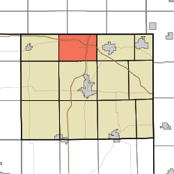 Location in Steuben County | |
| Coordinates: 41°43′51″N 85°01′43″W / 41.73083°N 85.02861°WCoordinates: 41°43′51″N 85°01′43″W / 41.73083°N 85.02861°W | |
| Country | United States |
| State | Indiana |
| County | Steuben |
| Government | |
| • Type | Indiana township |
| Area | |
| • Total | 23.68 sq mi (61.3 km2) |
| • Land | 20.7 sq mi (54 km2) |
| • Water | 2.98 sq mi (7.7 km2) 12.58% |
| Elevation[1] | 974 ft (297 m) |
| Population (2010) | |
| • Total | 3,249 |
| • Density | 157/sq mi (61/km2) |
| Time zone | UTC-5 (Eastern (EST)) |
| • Summer (DST) | UTC-4 (EDT) |
| Area code(s) | 260 |
| GNIS feature ID | 453476 |
Jamestown Township is one of twelve townships in Steuben County, Indiana, United States. As of the 2010 census, its population was 3,249 and it contained 2,937 housing units.[2]
History
Pokagon State Park, Collins School, and CCC Shelter are listed on the National Register of Historic Places.[3]
Geography
According to the 2010 census, the township has a total area of 23.68 square miles (61.3 km2), of which 20.7 square miles (54 km2) (or 87.42%) is land and 2.98 square miles (7.7 km2) (or 12.58%) is water.[2] Lakes in this township include Barton Lake, Big Otter Lake, Failing Lake, Green Lake, Hog Lake, Jimmerson Lake, Lake Charles West, Lake Lonidaw, Lake Minfenokee, Little Otter Lake, Lone Hickory Lake, Long Beach Lake, Marsh Lake, Middle Basin of Lake James, Seven Sisters Lakes, Snow Lake and the Upper Basin of Lake James. The stream of Follette Creek runs through this township.
Unincorporated towns
- Jamestown at 41°44′54″N 85°01′03″W / 41.7483836°N 85.0174646°W
- Lake James at 41°42′18″N 85°02′54″W / 41.7050503°N 85.0482994°W
- Nevada Mills at 41°43′37″N 85°04′56″W / 41.7269947°N 85.0821895°W
- Potawatomi Inn (a hotel in Pokagon State Park)
- Valley Outlet Center (a shopping center)
(This list is based on USGS data and may include former settlements.)
Cemeteries
The township contains one cemetery, Jamestown.
Major highways
Education
Jamestown Township residents may obtain a free library card from the Fremont Public Library.[4]
References
- "Jamestown Township, Steuben County, Indiana". Geographic Names Information System. United States Geological Survey. Retrieved 2009-09-24.
- United States Census Bureau cartographic boundary files
- ↑ "US Board on Geographic Names". United States Geological Survey. October 25, 2007. Retrieved 2017-05-08.
- 1 2 "Population, Housing Units, Area, and Density: 2010 - County -- County Subdivision and Place -- 2010 Census Summary File 1". United States Census. Retrieved 2013-05-10.
- ↑ National Park Service (2010-07-09). "National Register Information System". National Register of Historic Places. National Park Service.
- ↑ "Circulation Policies". Fremont Public Library. Retrieved 15 March 2018.
External links
Places adjacent to Jamestown Township, Steuben County, Indiana | |
|---|---|
Municipalities and communities of Steuben County, Indiana, United States | ||
|---|---|---|
| City | ||
| Towns | ||
| Townships | ||
| Unincorporated communities |
| |
| Footnotes | ‡This populated place also has portions in an adjacent county or counties | |