Ostankinsky District
| Ostankinsky District | |
|---|---|
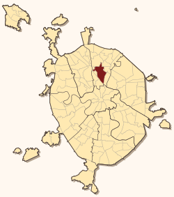 Location of Ostankinsky District on the map of Moscow | |
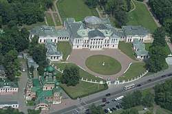 Ostankino Palace, from the observation deck of the Ostankino Tower, Ostankinsky District | |
.png) |
.png) |
|
| |
| Location | |
| Country | Russia |
| Federal subject | Moscow |
| Statistics | |
| Time zone | MSK (UTC+03:00)[1] |
| Official website | |
| Ostankinsky District on WikiCommons | |
Ostankinsky District , also called simply Ostankino, is an administrative district (raion) of North-Eastern Administrative Okrug, and one of the 125 raions of Moscow, Russia.[2] VDNH exhibition center and Ostankino Tower, the tallest structure in Europe, are located in Ostankinsky. The district is served by Moscow Monorail. Ostankinsky district is named after Ostankino village that existed on its site before urbanization.
See also
References
Notes
- ↑ Правительство Российской Федерации. Федеральный закон №107-ФЗ от 3 июня 2011 г. «Об исчислении времени», в ред. Федерального закона №271-ФЗ от 03 июля 2016 г. «О внесении изменений в Федеральный закон "Об исчислении времени"». Вступил в силу по истечении шестидесяти дней после дня официального опубликования (6 августа 2011 г.). Опубликован: "Российская газета", №120, 6 июня 2011 г. (Government of the Russian Federation. Federal Law #107-FZ of June 31, 2011 On Calculating Time, as amended by the Federal Law #271-FZ of July 03, 2016 On Amending Federal Law "On Calculating Time". Effective as of after sixty days following the day of the official publication.).
- ↑ Государственный комитет Российской Федерации по статистике. Комитет Российской Федерации по стандартизации, метрологии и сертификации. №ОК 019-95 1 января 1997 г. «Общероссийский классификатор объектов административно-территориального деления. Код 45», в ред. изменения №278/2015 от 1 января 2016 г.. (State Statistics Committee of the Russian Federation. Committee of the Russian Federation on Standardization, Metrology, and Certification. #OK 019-95 January 1, 1997 Russian Classification of Objects of Administrative Division . Code 45, as amended by the Amendment #278/2015 of January 1, 2016. ).
Sources
| Central Administrative Okrug |  | |
|---|---|---|
| Northern Administrative Okrug | ||
| North-Eastern Administrative Okrug | ||
| Eastern Administrative Okrug | ||
| South-Eastern Administrative Okrug | ||
| Southern Administrative Okrug | ||
| South-Western Administrative Okrug | ||
| Western Administrative Okrug | ||
| North-Western Administrative Okrug | ||
| Zelenogradsky Administrative Okrug | ||
| Novomoskovsky Administrative Okrug |
| |
| Troitsky Administrative Okrug |
| |
Coordinates: 55°49′50″N 37°37′16″E / 55.83056°N 37.62111°E
This article is issued from
Wikipedia.
The text is licensed under Creative Commons - Attribution - Sharealike.
Additional terms may apply for the media files.