Oshawa, Cass County, Minnesota
| Oshawa, Cass County, Minnesota | |
|---|---|
| Unincorporated community | |
 Oshawa, Cass County, Minnesota Location of the community of Oshawa within Cass County  Oshawa, Cass County, Minnesota Oshawa, Cass County, Minnesota (the US) | |
| Coordinates: 46°48′14″N 94°38′20″W / 46.80389°N 94.63889°WCoordinates: 46°48′14″N 94°38′20″W / 46.80389°N 94.63889°W | |
| Country | United States |
| State | Minnesota |
| County | Cass |
| Township | Bull Moose Township and Deerfield Township |
| Elevation | 1,483 ft (452 m) |
| Time zone | UTC-6 (Central (CST)) |
| • Summer (DST) | UTC-5 (CDT) |
| ZIP code | 56435 |
| Area code(s) | 218 |
| GNIS feature ID | 657687[1] |
Oshawa is an unincorporated community in Cass County, Minnesota, United States, near Backus. The community is located near the junction of Cass County Road 41 and State Highway 87 (MN 87). Oshawa is located within Bull Moose Township and Deerfield Township. The Badoura State Forest and the Foot Hills State Forest are both nearby.
A post office was established at Oshawa in 1916, and remained in operation until it was discontinued in 1944.[2][3]
References
- ↑ "Oshawa, Cass County, Minnesota". Geographic Names Information System. United States Geological Survey.
- ↑ "Cass County". Jim Forte Postal History. Retrieved 21 March 2015.
- ↑ U.S. Geological Survey Geographic Names Information System: Oshawa Post Office (historical)
Municipalities and communities of Cass County, Minnesota, United States | ||
|---|---|---|
| Cities | 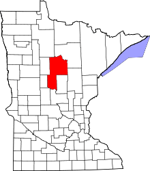 | |
| Townships |
| |
| Unorganized territories | ||
| CDP | ||
| Unincorporated communities | ||
| Indian reservation | ||
| Ghost town | ||
| Footnotes | ‡This populated place also has portions in an adjacent county or counties | |
This article is issued from
Wikipedia.
The text is licensed under Creative Commons - Attribution - Sharealike.
Additional terms may apply for the media files.