Ah-gwah-ching, Minnesota
| Ah-gwah-ching, Minnesota | |
|---|---|
| Unincorporated community | |
 Ah-gwah-ching, Minnesota Location of Ah-gwah-ching within Cass County  Ah-gwah-ching, Minnesota Ah-gwah-ching, Minnesota (the US) | |
| Coordinates: 47°04′27″N 94°33′46″W / 47.07417°N 94.56278°WCoordinates: 47°04′27″N 94°33′46″W / 47.07417°N 94.56278°W | |
| Country | United States |
| State | Minnesota |
| County | Cass |
| Township | Shingobee Township |
| Elevation | 1,335 ft (407 m) |
| Time zone | UTC-6 (Central (CST)) |
| • Summer (DST) | UTC-5 (CDT) |
| ZIP code | 56430 |
| Area code(s) | 218 |
| GNIS feature ID | 659097[1] |
Ah-gwah-ching is an unincorporated community in Shingobee Township, Cass County, Minnesota, United States, near Walker.
It is located along State Highways 200 (MN 200) and 371 (MN 371), two miles south-southeast of Walker. Ah-gwah-ching has the ZIP code 56430.[2]
The name Ah-gwah-ching means "out-of-doors" in the Ojibwe language.
References
- ↑ "Ah-gwah-ching, Minnesota". Geographic Names Information System. United States Geological Survey.
- ↑ ZIP Code Lookup Archived August 5, 2012, at the Wayback Machine.
Municipalities and communities of Cass County, Minnesota, United States | ||
|---|---|---|
| Cities | 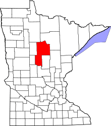 | |
| Townships |
| |
| Unorganized territories | ||
| CDP | ||
| Unincorporated communities | ||
| Indian reservation | ||
| Ghost town | ||
| Footnotes | ‡This populated place also has portions in an adjacent county or counties | |
This article is issued from
Wikipedia.
The text is licensed under Creative Commons - Attribution - Sharealike.
Additional terms may apply for the media files.