Orvin Mountains
| Orvin Mountains | |
|---|---|
|
Orvinfjella | |
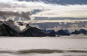 View looking to the west over Glopeken Glacier. Glopeken Glacier is located in the northern part of the Conrad Mountains, a subrange of the Orvin Mountains. | |
| Highest point | |
| Peak | Sandeggtind Peak |
| Elevation | 3,055 m (10,023 ft) |
| Coordinates | 72°00′00″S 09°00′00″E / 72.00000°S 9.00000°ECoordinates: 72°00′00″S 09°00′00″E / 72.00000°S 9.00000°E |
| Geography | |
 Orvin Mountains Map depicting the territorial extent of Queen Maud Land | |
| Continent | Antarctica |
| State/Province | Queen Maud Land, East Antarctica |
| Parent range | Fimbulheimen |
The Orvin Mountains (Norwegian: Orvinfjella) constitute a major group of mountain ranges, extending for about 100 km (62 mi) between the Wohlthat Mountains and the Mühlig-Hofmann Mountains in Queen Maud Land. With its summit at 3,055 metres (10,023 ft), the massive Sandeggtind Peak forms the highest point in the Conrad Mountains, a subrange of the Orvin Mountains.
Discovery and naming
First photographed from the air and roughly plotted by the Third German Antarctic Expedition (1938-1939), led by Capt. Alfred Ritscher. Mapped by Norwegian cartographers from surveys and air photos by the Sixth Norwegian Antarctic Expedition (1956–60) and named for Anders K. Orvin, director of the Norwegian Polar Institute from 1958 to 1959.[1]
Constituent ranges
Constituent ranges of Orvin Mountains, listed from east to west:
See also
References
- ↑ "Orvin Mountains". Geographic Names Information System. United States Geological Survey. Retrieved 31 May 2010.
![]()
| General |
| .svg.png) |
|---|---|---|
| Geographic regions | ||
| Waterways | ||
| Famous explorers | ||