Fimbulheimen
| Fimbulheimen | |
|---|---|
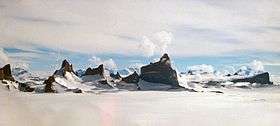 Drygalskiberge in the Fimbulheimen Mountains | |
| Highest point | |
| Peak | Jøkulkyrkja |
| Elevation | 3,148 m (10,328 ft) |
| Geography | |
 Fimbulheimen | |
Fimbulheimen is a mountain range in Queen Maud Land, Antarctica. It stretches from Jutulstraumen by 1° west of Carsten Borchgrevink Ice at 18° east, about 200 km from the ice edge. Fimbulheimen is thus between Maudheim Plateau and Sør-Rondane.
Dronning Maud's highest mountain, Jøkulkyrkja (elevation 3148 m), is located in Mühlig-Hofmann Mountains in Fimbulheimen. The name comes from Fimbulvetr, the harsh winter immediately preceding Ragnarok in Norse mythology.
A number of smaller ranges and mountain areas constitutes Fimbulheimen, from west to east:
- Gburek Peaks 72°10′00″S 0°16′00″W / 72.16667°S 0.26667°W
- Sverdrup Mountains 72°22′00″S 0°40′00″E / 72.36667°S 0.66667°E
- Gjelsvik Mountains 72°05′00″S 2°50′00″E / 72.08333°S 2.83333°E
- Mühlig-Hofmann Mountains 72°00′00″S 5°30′00″E / 72.00000°S 5.50000°E
- Orvin Mountains 71°55′00″S 9°00′00″E / 71.91667°S 9.00000°E
- Filchner Mountains 72°00′00″S 7°30′00″E / 72.00000°S 7.50000°E
- Drygalski Mountains 71°47′00″S 8°15′00″E / 71.78333°S 8.25000°E
- Kurze Mountains 71°50′00″S 9°00′00″E / 71.83333°S 9.00000°E
- Gagarin Mountains 71°58′00″S 9°23′00″E / 71.96667°S 9.38333°E
- Conrad Mountains 71°50′00″S 9°42′00″E / 71.83333°S 9.70000°E
- Mount Dallmann 71°45′00″S 10°20′00″E / 71.75000°S 10.33333°E
- Wohlthat Mountains 71°40′00″S 12°10′00″E / 71.66667°S 12.16667°E
- Hoel Mountains 72°00′00″S 14°00′00″E / 72.00000°S 14.00000°E
- Lomonosov Mountains 71°33′00″S 15°24′00″E / 71.55000°S 15.40000°E
The Norwegian research station Troll is located by Jutulsessen Mountain west in Fimbulheimen, while the ornithological field station Tor is about 100 km further east at Svarthamaren Mountain in Mühlig-Hofmann Mountains.
Large parts of the area were mapped by the Norwegian Antarctic Expedition 1956-60. The Norwegian Polar Institute has published twelve map sheets of Fimbulheimen in scale 1:250 000.[1]
References
- ↑ Mapping of Dronning Maud Land, Norwegian Polar Institute
Coordinates: 72°00′S 005°30′E / 72.000°S 5.500°E