Orth an der Donau
| Orth an der Donau | ||
|---|---|---|
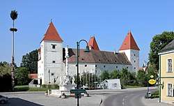 Castle and the Marian column | ||
| ||
 Orth an der Donau Location within Austria | ||
| Coordinates: 48°8′40″N 16°42′05″E / 48.14444°N 16.70139°ECoordinates: 48°8′40″N 16°42′05″E / 48.14444°N 16.70139°E | ||
| Country | Austria | |
| State | Lower Austria | |
| District | Gänserndorf | |
| Government | ||
| • Mayor | Johann Mayer (ÖVP) | |
| Area | ||
| • Total | 33.41 km2 (12.90 sq mi) | |
| Elevation | 150 m (490 ft) | |
| Population (1 January 2016)[1] | ||
| • Total | 2,070 | |
| • Density | 62/km2 (160/sq mi) | |
| Time zone | UTC+1 (CET) | |
| • Summer (DST) | UTC+2 (CEST) | |
| Postal code | 2304 | |
| Area code | 02212 | |
| Website |
www | |

Orth an der Donau is a town in the district of Gänserndorf in the Austrian state of Lower Austria.
Geography
It is located on the bank of the Danube River, about 15 miles east of Vienna and 17 miles west of Bratislava.[2]
History
In 1170, Hartneid von Orthe purchased the village and estate surrounding it, founded a church, and erected a castle. It remained in the family for several successive generations, when the proprietor, about the close of the 17th century, sold out and moved to Moravia.[2]
References
- ↑ Statistik Austria - Bevölkerung zu Jahresbeginn 2002-2016 nach Gemeinden (Gebietsstand 1.1.2016) for Orth an der Donau.
- 1 2 Egle, William Henry (1886). Genealogical Record of the Families of Beatty, Egle, Müller, Murray, Orth and Thomas. Harrisburg, PA: Lane S. Hart, Printer and Binder. p. 85.
This article is issued from
Wikipedia.
The text is licensed under Creative Commons - Attribution - Sharealike.
Additional terms may apply for the media files.