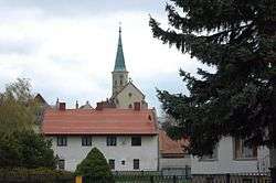
Hauskirchen
| Hauskirchen | ||
|---|---|---|
 | ||
| ||
 Hauskirchen Location within Austria | ||
| Coordinates: 48°37′N 16°45′E / 48.617°N 16.750°ECoordinates: 48°37′N 16°45′E / 48.617°N 16.750°E | ||
| Country | Austria | |
| State | Lower Austria | |
| District | Gänserndorf | |
| Government | ||
| • Mayor | Josef Huber | |
| Area | ||
| • Total | 22.04 km2 (8.51 sq mi) | |
| Elevation | 182 m (597 ft) | |
| Population (1 January 2016)[1] | ||
| • Total | 1,250 | |
| • Density | 57/km2 (150/sq mi) | |
| Time zone | UTC+1 (CET) | |
| • Summer (DST) | UTC+2 (CEST) | |
| Postal code | 2184 | |
| Area code | 02533 | |
| Website | www.hauskirchen-online.com | |

Hauskirchen is a town in the district of Gänserndorf in the Austrian state of Lower Austria.
Geography
Hauskirchen lies in the northeast Weinviertel in Lower Austria 15 kilometers east of Mistelbach. The Zaya River runs through the municipality. The area covers 22.04 square kilometers. Only about 3.95 percent of the municipality is forested.
Constituent communities
The municipality comprises the three villages (number of inhabitants as of January 1, 2015)
- Hauskirchen (588)
- Prinzendorf Zaya (485)
- Rannersdorf an der Zaya (170)
Hauskirchen is surrounded of the communities Großkrut, Neusiedl an der Zaya, Wilfersdorf and Zistersdorf.
History
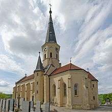
An early written records tells of the construction of a church and of the establishment of a parish in 1150 by Hugo von Liechtenstein.
Population Development
According to the results of the 2001 census, there were 1265 inhabitants.
- 1991 1273 inhabitants
- 1981 1364 inhabitants
- 1971 1450 inhabitants.
Politics
Mayor of the Municipality is Helmut Arzt (ÖVP). Office manager is Monika Geyer. In the council is after the local elections in Lower Austria 2015 the following mandate distribution (total of 19 seats):
- ÖVP 16
- SPÖ 3