Orduña-Urduña
| Orduña | |||
|---|---|---|---|
| Municipality | |||
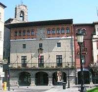 Orduña Town Hall | |||
| |||
 Orduña Location of Orduña within the Basque Country | |||
| Coordinates: 42°59′45″N 3°00′30″W / 42.99583°N 3.00833°WCoordinates: 42°59′45″N 3°00′30″W / 42.99583°N 3.00833°W | |||
| Country | Spain | ||
| Autonomous community | Basque Country | ||
| Province | Biscay | ||
| Comarca | Arrati-Nerbioi | ||
| Founded | 1229 | ||
| Government | |||
| • Mayor | Idoia Aginako Arbaiza (EH Bildu) | ||
| Area | |||
| • Total | 33.49 km2 (12.93 sq mi) | ||
| Elevation | 293 m (961 ft) | ||
| Population (2014) | |||
| • Total | 4,261 | ||
| • Density | 130/km2 (330/sq mi) | ||
| Demonym(s) | Spanish: orduñés | ||
| Time zone | UTC+1 (CET) | ||
| • Summer (DST) | UTC+2 (CEST) | ||
| Postal code | 48460 | ||
| Official language(s) |
Basque Spanish | ||
| Website | Official website | ||


Orduña (Basque: Urduña), officially Orduña-Urduña is an enclave and municipality of 4,057 inhabitants located in the province of Biscay, in the autonomous community of Basque Country, in the North of Spain.
It is located in a plain in the highest part of the Nervion river valley, at the foot of the Sierra Salbada mountains. The municipality is an exclave of Biscay, located between Álava and Burgos provinces.
Orduña is the final station of the commuter rail line C-3 that links the town with Bilbao.
.jpg)
View of the valley of Orduña

Train station
External links
- http://www.orduna.org: Local (in Spanish)
- ORDUÑA in the Bernardo Estornés Lasa - Auñamendi Encyclopedia (Euskomedia Fundazioa) (in Spanish)
- Apuntaciones históricas de la Ciudad de Orduña. José Antonio de Armona y Murga, 1789 (in Spanish)
This article is issued from
Wikipedia.
The text is licensed under Creative Commons - Attribution - Sharealike.
Additional terms may apply for the media files.