Sopuerta
| Sopuerta | |
|---|---|
| Municipality | |
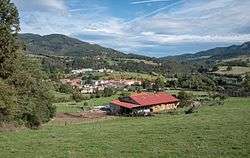 View of Sopuerta | |
 Sopuerta Location of Sopuerta within the Basque Country | |
| Coordinates: 43°15′46″N 3°09′09″W / 43.26278°N 3.15250°WCoordinates: 43°15′46″N 3°09′09″W / 43.26278°N 3.15250°W | |
| Country | Spain |
| Autonomous community | Basque Country |
| Province | Biscay |
| Comarca | Enkarterri |
| Government | |
| • Mayor | Joseba Andoni Llaguno Hurtado (Bildu) |
| Area | |
| • Total | 42.8 km2 (16.5 sq mi) |
| Elevation | 86 m (282 ft) |
| Population (2014) | |
| • Total | 2,563 |
| • Density | 60/km2 (160/sq mi) |
| Demonym(s) |
Spanish: soportano soportana |
| Time zone | UTC+1 (CET) |
| • Summer (DST) | UTC+2 (CEST) |
| Postal code | 48190 |
| Official language(s) |
Basque Spanish |
| Website | Official website |
Sopuerta is a town and municipality located in the province of Biscay, in the Autonomous Community of Basque Country, northern Spain.[1]
Neighborhoods
Sopuerta is administratively divided into 12 neighborhoods or wards:[2]
- Mercadillo
- Alen
- Arenao
- Avellaneda
- Baluga
- Olabarrieta
- Bezi
- Castaño
- Jarralta
- Las Muñecas
- Las Ribas
- Carral
Demography
| 1897 | 1900 | 1910 | 1920 | 1930 | 1940 | 1950 | 1960 | 1970 | 1981 | 1991 | 2001 | 2006 |
|---|---|---|---|---|---|---|---|---|---|---|---|---|
| 2,220 | 2,847 | 4,391 | 4,308 | 3,586 | 3,367 | 2,881 | 3,006 | 2,328 | 2,189 | 2,160 | 2,245 | 2,361 |
References
- ↑ Ainhoa Arozamena. "Auñamendi Encyclopedia: Sopuerta" (in Spanish). Eusko Ikaskuntza. Retrieved 2 July 2010.
- ↑ Euskaltzaindia. "Euskal Onomastikaren Datutegia (EODA): Sopuerta" (in Basque). Euskaltzaindia. Retrieved 2 July 2010.
This article is issued from
Wikipedia.
The text is licensed under Creative Commons - Attribution - Sharealike.
Additional terms may apply for the media files.