Oliana
| Oliana | ||
|---|---|---|
| Municipality | ||
 | ||
| ||
 Oliana Location in Catalonia | ||
| Coordinates: 42°04′N 1°19′E / 42.067°N 1.317°ECoordinates: 42°04′N 1°19′E / 42.067°N 1.317°E | ||
| Country |
| |
| Community |
| |
| Province | Lleida | |
| Comarca | Alt Urgell | |
| Government | ||
| • Mayor | Miquel Sala Muntada (2015)[1] | |
| Area[2] | ||
| • Total | 32.4 km2 (12.5 sq mi) | |
| Elevation | 469 m (1,539 ft) | |
| Population (2014)[1] | ||
| • Total | 1,870 | |
| • Density | 58/km2 (150/sq mi) | |
| Website |
oliana | |

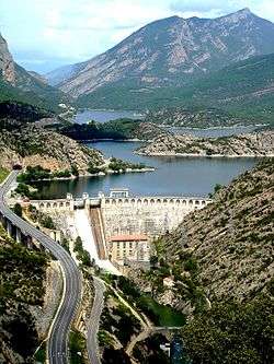
Oliana is a municipality in the comarca of the Alt Urgell in Catalonia, Spain. It is situated in the Segre valley immediately below the Oliana reservoir. There is a factory of domestic electrical appliances in the town, and the presence of non-farming employment has meant that Oliana has escaped the depopulation experienced by most municipalities in north-west Catalonia. It is currently the second-largest town (by population) in the Alt Urgell, behind the comarcal capital La Seu d'Urgell. The town is served by the C-14 road between Ponts and La Seu d'Urgell.
Demography
| 1900 | 1930 | 1950 | 1970 | 1986 | 2005 |
|---|---|---|---|---|---|
| 986 | 1127 | 1793 | 1793 | 2075 | 1932 |
Subdivisions
The municipality of Oliana includes two outlying villages. Populations are given as of 2001:
- Les Anoves (27)
- El Castell (73)
Features
The region is well known among rock climbers for its extremely difficult limestone cliffs, including La Dura Dura ("the hardest of the hard") which was until 2017 the hardest climb successfully undertaken in the world.
References
- 1 2 "Ajuntament d'Oliana". Generalitat of Catalonia. Retrieved 2015-11-13.
- ↑ "El municipi en xifres: Oliana". Statistical Institute of Catalonia. Retrieved 2015-11-23.
External links
- Government data pages (in Catalan)
Places adjacent to Oliana | |
|---|---|
Municipalities of Alt Urgell | ||
|---|---|---|