Montgai
| Montgai | ||
|---|---|---|
| Municipality | ||
.jpg) Butsènit d'Urgell village | ||
| ||
 Montgai Location in Catalonia | ||
| Coordinates: 41°47′59″N 0°57′39″E / 41.79972°N 0.96083°ECoordinates: 41°47′59″N 0°57′39″E / 41.79972°N 0.96083°E | ||
| Country |
| |
| Community |
| |
| Province |
| |
| Comarca |
| |
| Government | ||
| • Mayor | Jaume Gilabert Torruella (2015)[1] | |
| Area[2] | ||
| • Total | 28.9 km2 (11.2 sq mi) | |
| Elevation | 286 m (938 ft) | |
| Population (2015)[1] | ||
| • Total | 663 | |
| • Density | 23/km2 (59/sq mi) | |
| Website |
www | |
Montgai is a municipality in the province of Lleida and autonomous community of Catalonia, Spain. It is situated in the valley of the river Sió among the hills of Bellmunt in the south and the mountains of Montclar in the north.
The municipality consists of two villages: Montgai and Butsènit d'Urgell.
Economy
The economy is based in the agricultural activities. The expansion of cultivated land is quite divided between dry and irrigated land.
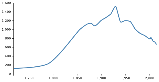
Population
In the 20th century Montgai had 27 houses, and increased the number of inhabitants until the 1930s. Then, it started a decrease because of economic crisis in the agriculture, and today there are 663 citizens.
Montgai: the village
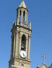
In the middle of the village there is the church Mare de Déu de l'Assumpció, built in the mid-eighteenth century.
Butsènit d'Urgell
.jpg)
References
- 1 2 "Ajuntament de Montgai". Generalitat of Catalonia. Retrieved 2015-11-13.
- ↑ "El municipi en xifres: Montgai". Statistical Institute of Catalonia. Retrieved 2015-11-23.
External links
- Government data pages (in Catalan)
Places adjacent to Montgai | |
|---|---|