Olean, Indiana
| Olean, Indiana | |
|---|---|
| Unincorporated community | |
 Olean  Olean | |
| Coordinates: 38°59′25″N 85°13′07″W / 38.9903339°N 85.2185683°WCoordinates: 38°59′25″N 85°13′07″W / 38.9903339°N 85.2185683°W | |
| Country | United States |
| State | Indiana |
| County | Ripley |
| Township | Brown |
| Elevation[1] | 955 ft (291 m) |
| Time zone | UTC-5 (Eastern (EST)) |
| • Summer (DST) | UTC-4 (EDT) |
| ZIP code | 47882 |
| Area code(s) | 812, 930 |
| GNIS feature ID | 440628 |
Olean is an unincorporated community in Brown Township, Ripley County, in the U.S. state of Indiana.[2]
History
Olean was laid out in 1858.[3] The community was named after Olean, New York.[4] A post office was established at Olean in 1844, and remained in operation until it was discontinued in 1905.[5]
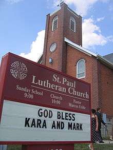
St. Paul Lutheran Church in Olean in 2007
St. Paul Lutheran Church in Olean was recognized by the Indiana Senate in 2007 on its 150th anniversary.[6]
Geography
Olean lies on Indiana State Road 129 about 6 miles (9.7 km) south of Versailles and Versailles State Park. Cross Plains is 3.3 miles (5.3 km) south of Olean, and Friendship about 6.5 miles (10.5 km) southeast.
References
- ↑ "US Board on Geographic Names". United States Geological Survey. October 25, 2007. Retrieved 2017-03-05.
- ↑ "Olean, Indiana". Geographic Names Information System. United States Geological Survey. Retrieved July 29, 2017.
- ↑ "The Start of Ripley County, Indiana". Ripley County, Indiana Historical Society. Retrieved 30 November 2015.
- ↑ Baker, Ronald L. (October 1995). From Needmore to Prosperity: Hoosier Place Names in Folklore and History. Indiana University Press. p. 251. ISBN 978-0-253-32866-3.
The name is for Olean, New York...
- ↑ "Ripley County". Jim Forte Postal History. Retrieved March 5, 2017.
- ↑ "Passed Senate Resolution 17". Indiana Senate First Regular Session 115th General Assembly. 2007.
Municipalities and communities of Ripley County, Indiana, United States | ||
|---|---|---|
| City | ||
| Towns | ||
| Townships | ||
| Unincorporated communities |
| |
| Ghost town | ||
| Footnotes | ‡This populated place also has portions in an adjacent county or counties | |
This article is issued from
Wikipedia.
The text is licensed under Creative Commons - Attribution - Sharealike.
Additional terms may apply for the media files.