Ohio State Route 64
| ||||
|---|---|---|---|---|
 | ||||
| Route information | ||||
| Maintained by ODOT | ||||
| Length | 36.47 mi[1][2][3] (58.69 km) | |||
| Existed | 1923[4][5] – present | |||
| Major junctions | ||||
| South end |
| |||
|
| ||||
| North end | Michigan state line near Metamora | |||
| Location | ||||
| Counties | Wood, Lucas, Fulton | |||
| Highway system | ||||
| ||||

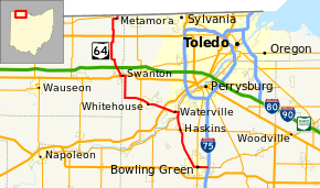
State Route 64 (SR 64) is a 36.44-mile (58.64 km) long north–south state highway in the northwestern portion of the U.S. state of Ohio. The southern terminus of SR 64 is at an interchange with Interstate 75 (I-75) in Bowling Green which also doubles as the western terminus of SR 105. Its northern terminus is at the Michigan state line just 0.25 miles (0.40 km) north of the village limits of Metamora. Continuing north into Michigan's Lenawee County is county-maintained Loar Highway.
Route description
SR 64 traverses portions of Wood, Lucas and Fulton Counties. There is no portion of this route that is included within the National Highway System (NHS). The NHS is a network of highways identified as being most important for the economy, mobility and defense of the country.[6]
History
The SR 64 designation was established in 1923. At its inception, SR 64 followed the majority of its present routing, traveling from downtown Bowling Green to its present northern terminus at the Michigan state line just outside Metamora.[4][5]
The only significant change to take place to the routing of SR 64 was an extension at the southern end that happened in 1969. Coinciding with the completions of both I-75 on the east side of Bowling Green, and the U.S. Route 6 (US 6) bypass of the city to the south, SR 64 was extended east from the present SR 25 (former US 25) intersection in downtown Bowling Green along the former routing of US 6 on Main Street to its present southern terminus at the junction of I-75 and SR 105.[7][8]
Major junctions
| County | Location | mi[1][2][3] | km | Destinations | Notes |
|---|---|---|---|---|---|
| Wood | Bowling Green | 0.00 | 0.00 | Exit 181 (I-75); western terminus of SR 105 | |
| 2.29 | 3.69 | ||||
| Haskins | 9.15 | 14.73 | |||
| Middleton Township | 11.45 | 18.43 | Southern end of SR 65 concurrency | ||
| 12.01 | 19.33 | Northern end of SR 65 concurrency | |||
| Lucas | Waterville Township | 14.48 | 23.30 | Exit 63 (US 24) | |
| Waterville–Swanton township line | 18.57 | 29.89 | |||
| Swanton | 24.62 | 39.62 | Southern end of US 20A / SR 2 concurrency | ||
| Fulton | 25.35 | 40.80 | Northern end of US 20A / SR 2 concurrency | ||
| Amboy Township | 32.46 | 52.24 | Southern end of SR 120 concurrency | ||
| Metamora | 35.38 | 56.94 | Northern end of SR 120 concurrency | ||
| Amboy Township | 36.47 | 58.69 | Loar Highway | Michigan state line | |
1.000 mi = 1.609 km; 1.000 km = 0.621 mi
| |||||
References
Route map:
- 1 2 Ohio Department of Transportation. "Technical Services Straight Line Diagrams: SR 64, Wood County" (PDF). Retrieved 2012-01-06.
- 1 2 Ohio Department of Transportation. "Technical Services Straight Line Diagrams: SR 64, Lucas County" (PDF). Retrieved 2012-01-06.
- 1 2 Ohio Department of Transportation. "Technical Services Straight Line Diagrams: SR 64, Fulton County" (PDF). Retrieved 2012-01-06.
- 1 2 Map of Ohio State Highways (MrSID) (Map). Cartography by ODHPW. Ohio Department of Highways and Public Works. April 1922. Retrieved 2012-01-15.
- 1 2 Map of Ohio Showing State Routes (MrSID) (Map). Cartography by ODHPW. Ohio Department of Highways and Public Works. July 1923. Retrieved 2012-01-15.
- ↑ National Highway System: Ohio (PDF) (Map). Federal Highway Administration. December 2003. Retrieved 2012-01-15.
- ↑ Official Ohio Highway Map (MrSID) (Map). Cartography by ODOH. Ohio Department of Highways. 1967. Retrieved 2012-01-15.
- ↑ Official Ohio Highway Map (MrSID) (Map). Cartography by ODOH. Ohio Department of Highways. 1969. Retrieved 2012-01-15.