Ochakiv
| Ochakiv Очаків | |||
|---|---|---|---|
| City of regional significance | |||
 Ochakiviska district council and district administration | |||
| |||
 Ochakiv Location of Ochakiv  Ochakiv Ochakiv (Ukraine) | |||
| Coordinates: 46°37′07″N 31°32′21″E / 46.61861°N 31.53917°ECoordinates: 46°37′07″N 31°32′21″E / 46.61861°N 31.53917°E | |||
| Country |
| ||
| Oblast |
| ||
| Raion | Ochakiv City Municipality | ||
| Founded | 1492 | ||
| Government | |||
| • Mayor | Mykola Topchyi | ||
| Area | |||
| • Total | 12.49 km2 (4.82 sq mi) | ||
| Population (2015) | |||
| • Total | 14,491[1] | ||
| • Density | 1,076/km2 (2,790/sq mi) | ||
| Time zone | UTC+2 (EET) | ||
| • Summer (DST) | UTC+3 (EEST) | ||
| Postal code | 57500-57014 | ||
| Area code(s) | +380 5154 | ||
| Website | mrada.ochakiv.info | ||

Ochakiv also known as Ochakov (Ukrainian: Очаків, Russian: Очаков, Crimean Tatar: Özü, Romanian: Oceacov and Vozia, and Alektor (Ἀλέκτορος in Greek) is a small city in Mykolaiv Oblast (region) of southern Ukraine. Serving as the administrative center of Ochakiv Raion (district), the city itself does not belong to the raion and is designated as a city of regional significance. Population: 14,491 (2015 est.)[1]
For many years the city-fortress served as a capital of the Ottoman province (eyalet).
History
Establishment and names
.jpg)
.jpg)
.jpg)
The strip of land, on which Ochakov is located today, was inhabited by Thracians and Scythians in ancient times. It was known as a part of Great (i. e. European) Scythia. In the 7th and 6th centuries BC, Greek colonists had founded a commercial colony town, named Alektor, near the Thracian coast. Archaeological excavations also show that near the area was the old Milesian (ancient Greek) colony of Pontic Olbia; it is supposed that the same Greek expeditions settled Alektor.
In the 1st century BC, Alektor became a Roman colony and part of the Roman empire. The area was part of the space in which the Romanians' ethnogenesis took place, and was also more generally a place of passage for many migratory people and tribes. As a result of the migrations, the city fell and the inhabitants lived in small settlements built on the shores of the Bug and Dnieper Rivers.
During the Middle Ages the place was named Vozia by Romanians. The name is supposed to come from a plant known in Romanian as bozii or bozia (Sambucus ebulus), a medicinal herb frequently found there. The territory was a part of the Moldavian Brodnici rule. It fell under Tatar domination in the time of the Mongol invasion of Europe.
Alexandru cel Bun (Alexander I, the Good), ruler of Moldavia (r. 1400–1432), and his ally Vitovt or Vytautas, Grand Duke of Lithuania (r. 1392–1430), freed the Vozia territory and a fortress was built again close to Alektor's ruins. Later the stronghold will be mentioned in Russian chronics as Dashev.
In the 14th century the Senarega brothers, Genovese merchants and warriors, had settled a castle at the place called Lerici, very close to Vozia city. It was a good point for commerce with Romanians and Tatars, but the Senarega family's interference in Moldavia's internal affairs made the Moldavians from Cetatea Albă (today's Bilhorod-Dnistrovskyi) take the castle from them in 1455.
In 1492, Crimean Tatars took Vozia from the Moldavians and named it Özü-Cale, which literally meant "Dnieper-fortress". The name was also very similar to the then current Romanian Vozia. At that time, the city was also referred to as Kara-Kerman ("Black city") as an opposite to Cetatea Albă ("White City", hence the synonymous naming as Ak-Kerman), also taken by the Tatars and Turkish army from their once Moldavian rulers.
In 1493, the fortress was taken by the Moldavian's cossacks of Bohdan Gliński. Due to its strategic location the fortress was a site of contest for a long time between Moldavia, Moldavia's ally Zaporizhian Sich, the Polish–Lithuanian Commonwealth, and the Ottoman Empire.
At a later date it became the centre of an Ottoman sanjak which included Khajidereh (today Ovidiopol), Khadjibey (Odessa), and Dubossary, as well as some 150 villages, and Silistra Province, sometimes called Özi Province, to which it belonged. Khadjibey later became a sanjak centre of its own.
In 1600 Mihai Viteazul (Michael the Brave), Prince of Wallachia, freed the city for a short time.
Giovanni Battista Malbi noted in 1620 that the town and the land of Vozia, even if ruled by the Tatars, were inhabited by Romanians, describing them as having the Orthodox religion and a corrupt Latin-Italian language, with Slavic influences, as in those times the Old Slav language was the church language in all Romanian countries. The same ethnic note was made by Niccolo Barsi from Lucca in the same century. Daniel Krmann, a monk from Poltava, wrote that apart from the Turks and Tatars, the conquerors of Vozia, the city was inhabited by Moldavians (Romanians) and a number of Greek merchants.
Lawrin Piaczeczynski, secretary of the Polish king Sigismund III Vasa, traveling with a diplomatic mission to Gazi Ghirai Khan, traversing the region of Cetatea Albă (Ak-Kerman) and the Vozia or Oceakov region, found only "Moldavian villages under the Tatar Khan's domination, ruled in his name by Nazyl Aga" ("sate moldoveneşti pe care le ţine hanul tătărăsc şi pe care le guvernează în numele lui sluga lui Nazyl aga")[2] Similar notes were made by Giovanni Botero (1540–1617) in Relazioni universali (Venice 1591); Gian Lorenzo d'Anania in L'Universale fabbrica del Mondo, ovvero Cosmografia (Napoli 1573, Venice 1596 etc.) and Giovanni Antonio Magini (1555–1617), from Padova, în Geographie universae (Venice 1596).
Russian conquest
During the Russo-Turkish War (1735–1739), the Russian Empire, viewing the Ottoman fortress as the key for obtaining control of the Black Sea littoral, besieged it in 1737. Russian troops commanded by Marshal von Münnich took the fortress by storm (July 1737), but the following year Russia abandoned it, restoring it to Turkey in 1739. The 1737 siege became famous as the background to one of the tales of the fictional Baron Munchausen.
During the Russo-Turkish War of 1787–1792, Russian land forces under Alexander Suvorov and naval units commanded by John Paul Jones started a second siege of Ochakov, which began in the summer of 1788 and lasted six months. In December 1788, in temperatures of −23 °C (−9 °F), the Russians stormed the fortress, resulting in a terrible loss of life. The siege became the subject of a famous ode by Gavrila Derzhavin.[3] The naval Battle of Ochakov (July 1788) took place alongside the city during the same campaign. The Treaty of Jassy of 1792 transferred Özi to the Russian Empire, which renamed it as Ochakov (Russian: Оча́ков).
Initially the Russian Empire planned to establish a "New Moldavia" as a point of attraction for the Romanians from Moldavia, Wallachia and other Romanian-speaking areas.[4] But even if the Romanians (called Moldavians by the Russians) constituted the majority in the territory, they received no rights and were forced to assimilate. To achieve this goal the Russian Empire gave land to Slavic colonists.[5]
Anglo-French occupation
During the Crimean War the Kinburn Fortress opposite Ochakiv was bombarded by the Anglo-French fleet and captured on October 17, 1855, in the course of the Battle of Kinburn. The fortress remained in Anglo-French hands for the remaining months of the war, while the Russians abandoned Ochakiv and destroyed the fort located there. After that war the coastal defences around Ochakiv were rebuilt and strengthened.
Recent history
With the establishment of the Ukrainian statehood as the Ukrainian People's Republic the local (Ukrainian) name of the city became officially in use. Ochakiv was part of the Soviet Union's Ukrainian SSR and during World War II it was occupied by Romania between 1941 and 1944. This was the first time in the city's history that the ethnological and sociological research of Ochakiv's Romanians survivors were made by Anton Golopenția.[6]
Present
Today Ochakiv is a resort town and a fishing port. The current estimated population is around 16,900 (as of 2001).
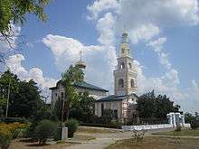
The town's main sight is the building of the Suvorov Museum, which served as a mosque in the 15th century. It was converted into the church of St. Nicholas in 1804 and was reconstructed in the pseudo-Russian style in 1842.
Ochakiv is home to a Ukrainian Navy’s operational control center.[7]
Not far from the city is located the Historical-Archaeological Preserve "Olvia" and Berezan Island. On the Kinburn peninsula are located the National park "White Bank of Svyatoslav" and the "Volzhyn forest" of Black Sea Biosphere Preserve.
Geography
The city is located right at the mouth of Dnieper, on the banks of the Dnieper-Bug Estuary. Between the Cape of Ochakiv (northern bank) and the Kinburn spit (southern bank) there are only 3.6 km (2.2 mi). Both Ochakiv and Kinburn fortresses composed a controlled entrance to Dnieper and Bug.
Notes
- 1 2 "Чисельність наявного населення України (Actual population of Ukraine)" (PDF) (in Ukrainian). State Statistics Service of Ukraine. Retrieved 1 July 2016.
- ↑ http://romaniancoins.org/rotransnistria.html
- ↑ https://ru.wikisource.org/wiki/%D0%9E%D1%81%D0%B5%D0%BD%D1%8C_%D0%B2%D0%BE_%D0%B2%D1%80%D0%B5%D0%BC%D1%8F_%D0%BE%D1%81%D0%B0%D0%B4%D1%8B_%D0%9E%D1%87%D0%B0%D0%BA%D0%BE%D0%B2%D0%B0_(%D0%94%D0%B5%D1%80%D0%B6%D0%B0%D0%B2%D0%B8%D0%BD)
- ↑ "Archived copy". Archived from the original on 2013-11-12. Retrieved 2014-11-03.
- ↑ Zaporojia-teritoriu de etnogeneza a poporului român
- ↑ . The whole research raport can be read here: Anton_Golopentia-Romanii_De_La_Est_De_Bug.
- ↑ Read more on UNIAN: https://www.unian.info/politics/2079834-ukrainian-interest-putins-maneuvers-waszczykowskis-advice-and-merkels-rating.html
stroitelstvo-ochakove-komandnogo-1502449040.html
External links
| Wikimedia Commons has media related to Ochakiv. |
![]()
| Raions | |||||
|---|---|---|---|---|---|
| Cities |
| ||||
| |||||