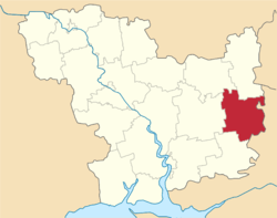
Bereznehuvate Raion
| Bereznehuvatskyi Raion Березнегуватський район | |||
|---|---|---|---|
| Raion | |||
| |||
 | |||
| Coordinates: 47°20′49″N 32°52′38″E / 47.34694°N 32.87722°ECoordinates: 47°20′49″N 32°52′38″E / 47.34694°N 32.87722°E | |||
| Country |
| ||
| Region | Mykolaiv Oblast | ||
| Established | 1923 | ||
| Admin. center | Bereznehuvate | ||
| Subdivisions |
List
| ||
| Government | |||
| • Governor | Anatoliy Kruts | ||
| Area | |||
| • Total | 1,263 km2 (488 sq mi) | ||
| Population (2015) | |||
| • Total |
| ||
| Time zone | UTC+2 (EET) | ||
| • Summer (DST) | UTC+3 (EEST) | ||
| Postal index | 56200—56254 | ||
| Area code | +380 5168 | ||
Bereznehuvate Raion (Ukrainian: Березнегуватський район) is located in Mykolaiv Oblast of Ukraine. Its administrative center is the urban-type settlement of Bereznehuvate. Population: 20,602 (2015 est.)[1]
History
Administratively, since 1776 the area belonged to Khersonsky Uyezd, which was shuffled between different governorates of the Russian Empire: Yekaterinoslav Viceroyalty until 1795, Voznesensk Viceroyalty until 1796, Novorossiya Governorate until 1803, Kherson Governorate until 1920,[2] Nikolayev Governorate until 1921, and Odessa Governorate until 1923, when uyezds were abolished in the Ukrainian Soviet Socialist Republic; the governorates were divided into okruhas. In 1923, Bereznehuvate Raion of Kherson Okruha, with the administrative center in Bereznehuvate, was established.[3] In 1925, the governorates were abolished, and okruhas were directly subordinated to Ukrainian SSR. In 1930, okruhas were abolished. In 1935, Bereznehuvate Raion was transferred into Odessa Oblast.[4] On 22 September 1937, Mykolaiv Oblast was established on lands which previously belonged to Dnipropetrovsk and Odessa Oblasts, and Bereznehuvate Raion became part of newly created Mykolaiv Oblast.[5]
In March and April 1944, Bereznegovatoye–Snigirevka Offensive, a part of major Dnieper–Carpathian Offensive of the Soviet army during the last phase of World War II, took place around Bereznehuvate.
References
- 1 2 "Чисельність наявного населення України (Actual population of Ukraine)" (PDF) (in Ukrainian). State Statistics Service of Ukraine. Retrieved 1 July 2016.
- ↑ "Березнеговатое в XVIII-XX веках: история Николаевщины" (in Russian). Николаевские Известия. 12 December 2015. Retrieved 5 March 2016.
- ↑ Вся Одещина. Odessa: Odessa Okruha. 1926. p. 410.
- ↑ "Становление и развитие" (in Russian). Одесские известия. Retrieved 12 March 2016.
- ↑ "Районы Николаевской области" (in Russian). Николаевская область. Электронная историческая энциклопедия. Retrieved 6 March 2016.
| Raions | |||||
|---|---|---|---|---|---|
| Cities |
| ||||
| |||||