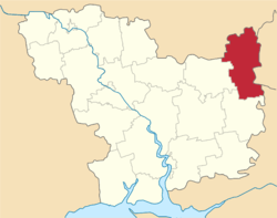
Kazanka Raion
| Kazankivskyi Raion Казанківський район | |||
|---|---|---|---|
| Raion | |||
| |||
 | |||
| Coordinates: 47°45′45″N 32°53′10″E / 47.76250°N 32.88611°ECoordinates: 47°45′45″N 32°53′10″E / 47.76250°N 32.88611°E | |||
| Country |
| ||
| Region | Mykolaiv Oblast | ||
| Established | 1923 | ||
| Admin. center | Kazanka | ||
| Subdivisions |
List
| ||
| Government | |||
| • Governor | Vasyl Skrypnik | ||
| Area | |||
| • Total | 1,349 km2 (521 sq mi) | ||
| Population (2015) | |||
| • Total |
| ||
| Time zone | UTC+2 (EET) | ||
| • Summer (DST) | UTC+3 (EEST) | ||
| Postal index | 56000—56067 | ||
| Area code | +380 5164 | ||

Kazanka Raion (Ukrainian: Казанківський район) is located in Mykolaiv Oblast of Ukraine. Its administrative center is the urban-type settlement of Kazanka. Population: 19,886 (2015 est.)[1]
History
In 1923, Kazanka Raion of Kryvyi Rih Okruha, with the administrative center in Kazanka, was established as part of Yekaterinoslav Governorate. In 1925, the governorates were abolished, and okruhas were directly subordinated to Ukrainian SSR. In 1930, okruhas were abolished, and on 27 February 1932, Dnipropetrovsk Oblast was established, and Kazanka Raion was included into Dnipropetrovsk Oblast. On 22 September 1937, Mykolaiv Oblast was established on lands which previously belonged to Dnipropetrovsk and Odessa Oblasts, and Kazanka Raion became part of newly created Mykolaiv Oblast. In 1967, Kazanka was granted urban-type settlement status.[2]
References
- 1 2 "Чисельність наявного населення України (Actual population of Ukraine)" (PDF) (in Ukrainian). State Statistics Service of Ukraine. Retrieved 1 July 2016.
- ↑ "Районы Николаевской области" (in Russian). Николаевская область. Электронная историческая энциклопедия. Retrieved 8 March 2016.
| Raions | |||||
|---|---|---|---|---|---|
| Cities |
| ||||
| |||||