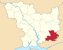
Snihurivka Raion
| Snihurivskyi Raion Снігурівський район | |||
|---|---|---|---|
| Raion | |||
| |||
 | |||
| Coordinates: 46°59′51″N 32°42′4″E / 46.99750°N 32.70111°ECoordinates: 46°59′51″N 32°42′4″E / 46.99750°N 32.70111°E | |||
| Country |
| ||
| Region | Mykolaiv Oblast | ||
| Established | 1923 | ||
| Admin. center | Snihurivka | ||
| Subdivisions |
List
| ||
| Government | |||
| • Governor | Sergiy Kulazhin | ||
| Area | |||
| • Total | 1,395 km2 (539 sq mi) | ||
| Population (2015) | |||
| • Total |
| ||
| Time zone | UTC+2 (EET) | ||
| • Summer (DST) | UTC+3 (EEST) | ||
| Postal index | 57300—57378 | ||
| Area code | +380 5162 | ||
Snihurivka Raion (Ukrainian: Снігурівський район) is located in Mykolaiv Oblast of Ukraine. Its administrative center is the town of Snihurivka. Population: 40,772 (2015 est.)[1]
References
- 1 2 "Чисельність наявного населення України (Actual population of Ukraine)" (PDF) (in Ukrainian). State Statistics Service of Ukraine. Retrieved 1 July 2016.
| Raions | |||||
|---|---|---|---|---|---|
| Cities |
| ||||
| |||||
This article is issued from
Wikipedia.
The text is licensed under Creative Commons - Attribution - Sharealike.
Additional terms may apply for the media files.