Nové Zámky District
| Nové Zámky District | |
|---|---|
| District | |
 | |
| Country | Slovakia |
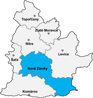
| Region (kraj) | Nitra Region |
| Area | |
| • Total | 1,347 km2 (520 sq mi) |
| Population (2001) | |
| • Total | 149,594 |
| • Density | 110/km2 (290/sq mi) |
| Time zone | UTC+1 (CET) |
| • Summer (DST) | UTC+2 (CEST) |
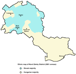
Ethnic map of Nové Zámky District (2001 census) - data by municipalities.
Nové Zámky District (okres Nové Zámky) is a district in the Nitra Region of western Slovakia. Until 1918, the area of the district was split between several county of Kingdom of Hungary: the largest area in the north formed part of Nitra; an area in the south between Dvory nad Žitavou and Strekov formed part of Komárno; an area in the north-east around Veľké Lovce formed part of Tekov; a sizable area in the east formed part of Esztergom (Ostrihom); and a small area around Salka formed part of Hont County.
Municipalities
- Andovce
- Bajtava
- Bánov
- Bardoňovo
- Belá
- Bešeňov
- Bíňa
- Branovo
- Bruty
- Čechy
- Černík
- Chľaba
- Dedinka
- Dolný Ohaj
- Dubník
- Dvory nad Žitavou
- Gbelce
- Hul
- Jasová
- Jatov
- Kamenica nad Hronom
- Kamenín
- Kamenný Most
- Kmeťovo
- Kolta
- Komjatice
- Komoča
- Leľa
- Lipová
- Ľubá
- Malá nad Hronom
- Malé Kosihy
- Maňa
- Michal nad Žitavou
- Mojzesovo
- Mužla
- Nána
- Nová Vieska
- Nové Zámky
- Obid
- Palárikovo
- Pavlová
- Podhájska
- Pozba
- Radava
- Rastislavice
- Rúbaň
- Salka
- Šarkan
- Semerovo
- Sikenička
- Strekov
- Štúrovo
- Šurany
- Svodín
- Trávnica
- Tvrdošovce
- Úľany nad Žitavou
- Veľké Lovce
- Veľký Kýr
- Vlkas
- Zemné
| Wikimedia Commons has media related to Nové Zámky District. |
Districts of Nitra Region | ||
|---|---|---|
Coordinates: 47°59′10″N 18°9′51″E / 47.98611°N 18.16417°E
This article is issued from
Wikipedia.
The text is licensed under Creative Commons - Attribution - Sharealike.
Additional terms may apply for the media files.