Podhájska
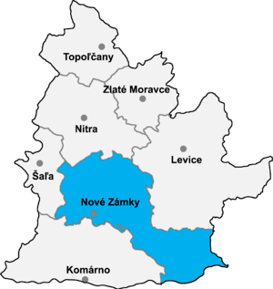
Nové Zámky District in the Nitra region
Podhájska (Hungarian: Bellegszencse) is a village and municipality in the Nové Zámky District in the Nitra Region of south-west Slovakia.
History
In historical records the village was first mentioned in 1075.
Geography
The municipality lies at an altitude of 141 metres and covers an area of 11.116 km². It has a population of about 1156 people.
Climate
The Köppen Climate Classification subtype for this climate is "Dfb" (Warm Summer Continental Climate).[1]
| Climate data for Podhájska | |||||||||||||
|---|---|---|---|---|---|---|---|---|---|---|---|---|---|
| Month | Jan | Feb | Mar | Apr | May | Jun | Jul | Aug | Sep | Oct | Nov | Dec | Year |
| Record high °C (°F) | 17.4 (63.3) |
19.8 (67.6) |
25.6 (78.1) |
30.3 (86.5) |
33.7 (92.7) |
37.5 (99.5) |
39.5 (103.1) |
40.2 (104.4) |
37.9 (100.2) |
28.4 (83.1) |
23.8 (74.8) |
19.1 (66.4) |
40.2 (104.4) |
| Average high °C (°F) | 1.6 (34.9) |
4.4 (39.9) |
10.4 (50.7) |
16.3 (61.3) |
21.4 (70.5) |
24.4 (75.9) |
26.6 (79.9) |
26.0 (78.8) |
21.5 (70.7) |
15.3 (59.5) |
7.7 (45.9) |
2.9 (37.2) |
14.9 (58.8) |
| Daily mean °C (°F) | −0.2 (31.6) |
1.1 (34) |
6.2 (43.2) |
11.7 (53.1) |
16.5 (61.7) |
19.6 (67.3) |
21.3 (70.3) |
20.8 (69.4) |
17.1 (62.8) |
11.7 (53.1) |
5.2 (41.4) |
0.8 (33.4) |
11 (52) |
| Average low °C (°F) | −2.3 (27.9) |
−0.1 (31.8) |
3.1 (37.6) |
7.4 (45.3) |
12.2 (54) |
15.4 (59.7) |
16.2 (61.2) |
15.7 (60.3) |
12.9 (55.2) |
8.1 (46.6) |
2.8 (37) |
−0.9 (30.4) |
7.5 (45.5) |
| Record low °C (°F) | −26.5 (−15.7) |
−23.9 (−11) |
−15.8 (3.6) |
−6.1 (21) |
−1.1 (30) |
4.3 (39.7) |
7.6 (45.7) |
7.1 (44.8) |
1.4 (34.5) |
−7.7 (18.1) |
−15.5 (4.1) |
−24.6 (−12.3) |
−26.5 (−15.7) |
| Average precipitation mm (inches) | 19.8 (0.78) |
20.1 (0.791) |
27.5 (1.083) |
38.1 (1.5) |
49.6 (1.953) |
60.2 (2.37) |
67.5 (2.657) |
66.9 (2.634) |
58.4 (2.299) |
53.2 (2.094) |
39.7 (1.563) |
25.4 (1) |
526.4 (20.724) |
| Average snowfall cm (inches) | 24.8 (9.76) |
20.3 (7.99) |
7.9 (3.11) |
2.1 (0.83) |
0.0 (0) |
0.0 (0) |
0.0 (0) |
0.0 (0) |
0.0 (0) |
0.8 (0.31) |
8.1 (3.19) |
21.9 (8.62) |
85.9 (33.82) |
| Average precipitation days (≥ 6.2) | 6.7 | 7.5 | 8.8 | 10.1 | 9.4 | 9.1 | 8.8 | 8.7 | 9.8 | 9.1 | 7.9 | 6.5 | 102.4 |
| Mean monthly sunshine hours | 68.9 | 98.9 | 140.4 | 189.6 | 221.1 | 248.2 | 265.5 | 256.3 | 199.8 | 129.5 | 78.6 | 46.7 | 1,943.5 |
| Source: Central Institute for Meteorology and Geodynamics[2] | |||||||||||||
Ethnicity
The population is about 99% Slovak.
Facilities
The village has a small public library a swimming pool and a football pitch.
External links
References
- ↑ Climate Summary
- ↑ "Klimadaten von Österreich 1971–2000 – Wien-Innere-Stadt" (in German). Central Institute for Meteorology and Geodynamics. Retrieved 16 February 2015.
Coordinates: 48°06′20″N 18°20′10″E / 48.10556°N 18.33611°E
This article is issued from
Wikipedia.
The text is licensed under Creative Commons - Attribution - Sharealike.
Additional terms may apply for the media files.