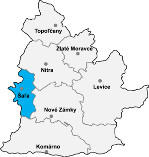
Šaľa District
| Šaľa District | |
|---|---|
| District | |
 | |
| Country | Slovakia |
| Region (kraj) | Nitra Region |
| Area | |
| • Total | 356 km2 (137 sq mi) |
| Population (2001) | |
| • Total | 54,000 |
| • Density | 150/km2 (390/sq mi) |
| Time zone | UTC+1 (CET) |
| • Summer (DST) | UTC+2 (CEST) |
| Telephone prefix | 31 |
Šaľa District (Slovak: okres Šaľa; Hungarian: Vágsellyei járás) is a district in the Nitra Region of western Slovakia. Until 1918, the district formed mostly part of the county of Kingdom of Hungary of Nyitra, apart from a small area in the west around Diakovce, Tešedíkovo and Žihárec which formed part of the county of Pressburg.
Municipalities
- Diakovce
- Dlhá nad Váhom
- Hájske
- Horná Kráľová
- Kráľová nad Váhom
- Močenok
- Neded
- Šaľa
- Selice
- Tešedíkovo
- Trnovec nad Váhom
- Vlčany
- Žihárec
Districts of Nitra Region | ||
|---|---|---|
This article is issued from
Wikipedia.
The text is licensed under Creative Commons - Attribution - Sharealike.
Additional terms may apply for the media files.