North Penajam Paser Regency
| North Penajam Paser Kabupaten Penajam Paser Utara | ||
|---|---|---|
| ||
| Nickname(s): PPU | ||
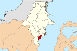 Location of PPU in East Kalimantan | ||
| Coordinates: 1°45′18.37″S 115°36′14.5″E / 1.7551028°S 115.604028°ECoordinates: 1°45′18.37″S 115°36′14.5″E / 1.7551028°S 115.604028°E | ||
| Country | Indonesia | |
| Province | East Kalimantan | |
| Government | ||
| • Regent | Yusran Aspar | |
| Area | ||
| • Total | 3,333.06 km2 (1,286.90 sq mi) | |
| Elevation | 0 m (0 ft) | |
| Population (2014 Census) | ||
| • Total | 165,552 | |
| • Density | 50/km2 (130/sq mi) | |
| Time zone | UTC+8 | |
| Website |
www | |

North Paser Regency is a regency in East Kalimantan province in Indonesia. Its capital city is Penajam. North Penajam Paser is a new regency, having been a part of Paser Regency until its separation in 2002.[1] North Penajam Paser Regency were the fifth largest area regencies in East Kalimantan province with 6 times larger than Balikpapan city.
Boundaries
- North : Kutai Kartanegara Regency
- East : Makassar Strait and Balikpapan City
- South : Paser Regency
- West : Paser Regency and West Kutai Regency
Economic
North Penajam Paser Regency major commodities are palm oil and timber that makes up over 70 percent of it economy. There's also some traditional mining coal, rice (paddy) fields, fishing, and harvesting that supplies the local market and Balikpapan cities market like fruits, eggs, chickens, seaweed, fish, etc. Mostly people here work at palm oil industries and the timber industries. Badly road coverage and peoples density that spreads over all the area slowing down the economic development. Penajam is the most populous area in a single area. There's no Mall at North Penajam regency, so the people cross the sea via "kelotok" or medium wooden boat or with ferry to go to Balikpapan to shopping. But its planned to connecting North Penajam Regency with Balikpapan with Sea Bridge which long almost 8 km and planned to start the construction of the bridge at 2018 to help growing up the economical development.
Administration
North Penajam Paser Regency is divided into four districts (kecamatan),[2] tabulated below with their 2010 Census population:[3]
| Name | Population Census 2010 |
|---|---|
| Babulu | 29,434 |
| Waru | 15,642 |
| Penajam | 66,983 |
| Sepaku | 30,863 |
Government & Politic
North Penajam Paser Regency Ruled by Major Yusran Aspar. The highest local political is Peoples Councils Area (Dewan Perwakilan Rakyat Daerah) which making political, economical, etc. decision for the sake of the region.
Military
North Penajam Paser regency are under the jurisdiction of Military District Command 0913 North Penajam Paser of Military Area Command V Mulawarman, and Police District North Penajam Paser under the Police Area Eastern Borneo province. Under Soeharto Dictatorship, the area controlled and secured mostly by the Military till the Indonesia Police separated from Indonesia Armed Force. In some circumstance, the military exercise placed here for survival training, jungle warfare, anti-terror, etc. Because the area mostly are virgin forest and its good for extremely military training field.
Transportation
With such a large area, North Penajam Paser regency only between 150–200 km road covered by asphalt and mostly road are still grounds or rocky. Only the protocol road covered by asphalt or cement, it's make the economical development can't growing faster than the expected. Mostly peoples using motorcycle for transport. Angkutan umum (Angkot) only can be found at the regency capital Penajam. Peoples mostly using bus, modified mini pick-up, and modified truck for mass transport. Take an Exams, a modified Isuzu Truck can hold up to 60 peoples each truck to transport workers, a modified Suzuki Carry can hold up to 16 peoples to transporting student from their villages to their school.
For the sea transport there's ferry, speed boat, medium wooden-engine boat up to 17 Meters, and heavy wooden-engine boat longest up to 35 meters using single propellers engine.
Tourism
Thousands Flowers Park
In North Penajam Paser Regency, there's a thousand flowers park beside the Police District Station at Penajam.
Beach tourism
For Beach Tourism, actually there's 3 Beach for Tourism. Pantai Lango (Lango Beach), Pantai Lawe-Lawe (Lawe-Lawe Beach), and pantai Senipah (Senipah Beach) that viewed Balikpapan City and Makassar's Strait. But in 2013, as the Sea Bridges Planned. Senipah Beach used for the cross point and fondated for the Bridges Construction.
Waterfalls
In Riko, there's a waterfall for tourism and there's another two waterfalls, one near ex. PT International Timber Corporation Indonesia area, and another deep to the jungle from Sepaku. Its location is kept secret by local people to secure the waterfall's protection from the effects of tourism.
Hiking
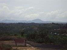
In Sepaku, there's a high mountain named "Parung" for local hiking and camping. Mount parung was a mountain upper the another mountain that can seen from 50 km away and there's a big Cave for Bats and Swallow Nest and pre-Historic giant stone formation at the peaks of Mount Parung.
Deer conservation
In Api-api Village, Waru District there are endemic sambar deer (Cervus unicolor) conservation with more than 200 deer.[4]
References
- ↑
- ↑
- ↑ Biro Pusat Statistik, Jakarta, 2011.
- ↑ Endri Kurniawati (August 19, 2014). "A Walk to Penajam Deer Conservation".
External links
Places adjacent to North Penajam Paser Regency | ||||||||||
|---|---|---|---|---|---|---|---|---|---|---|
| ||||||||||
Regencies and cities of East Kalimantan | ||
|---|---|---|
Capital: Samarinda | ||
| Regencies | ||
| Cities | ||