Normansville, New York
| Normansville | |
| Neighborhood; former hamlet | |
| Name origin: Normansville is situated in the ravine created by the Normans Kill Creek | |
| Country | United States |
|---|---|
| State | New York |
| Region | Capital District |
| County | Albany |
| Municipality | Bethlehem and Albany |
| River | Normans Kill |
| Coordinates | 42°38′01″N 73°47′57″W / 42.63361°N 73.79917°WCoordinates: 42°38′01″N 73°47′57″W / 42.63361°N 73.79917°W |
| Timezone | EST (UTC-5) |
| - summer (DST) | EDT (UTC-4) |
| ZIP Code | 12054 (Bethlehem side)/12209 (Albany side) |
| Area code | 518 |
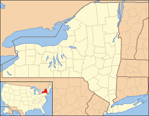 Location of Normansville within the state of New York | |
Normansville is a neighborhood in the town of Bethlehem, New York and in the city of Albany, New York.
In the 19th century, Normansville was a hamlet in the town of Bethlehem. Normansville is located within and along the north and south banks of the ravine carved by the Normans Kill Creek, a tributary of the Hudson River. In 1916, the portion of Normansville north of the Normans Kill was annexed by the city of Albany; that portion of Normansville is now a neighborhood within the City of Albany, while the portion of Normansville lying south of the Normans Kill is a neighborhood within the Town of Bethlehem.
History

in 1891

Normansville was originally called Upper Hollow; it was named for the deep ravine carved by the Normans Kill in which it was located. Further downstream was Lower Hollow, later named Kenwood. Upper Hollow had its start in 1805 with the construction of the Delaware Turnpike, which ran from the City of Albany to Otego (which then was part of Delaware County).[1] The Turnpike was carried over the Normans Kill ("kill" is the Dutch word for "stream") by a 100-foot-long (30 m) wooden bridge. Northwest of this bridge was a toll gate. The wood bridge was washed away by a freshet in 1869[2] (one year after the turnpike company had abandoned the Turnpike) and the Town of Bethlehem built an iron bridge in its place.[1][2]
Soon after the Turnpike was constructed, taverns and various industries began to spring up to take advantage of the power that could be harnessed from the Normans Kill's waters. Among the industries were cloth mills and saw mills. Several of these mills were swept aside by the same freshet that washed away the bridge in 1869, but were quickly rebuilt. By the beginning of the 20th century, the mills were abandoned.[2] Another major industry along the Normans Kill was the ice trade. Ice blocks from the Normans Kill during the winter and stored for shipping to New York City and other locations for use in iceboxes. The Pappalau Ice House on the north side of the creek was one of many ice houses along the Normans Kill and the Hudson River at the end of the 1800s; by 1920, it too would be abandoned as new technologies made the ice trade obsolete.[3]
In 1916, much of the boundary between Albany and the Town of Bethlehem was moved south to the Normans Kill.[4] This change split Normansville between the City of Albany and the Town of Bethlehem. Prior to this annexation, the children of Normansville attended a small school (Bethlehem District Number 11) in Normansville on the Delaware Turnpike. After the annexation, those Normansville children whose homes were now located in Albany attended the Albany city schools, and the Normansville children remaining in the Town of Bethlehem continued to attend school in District 11. Due to the annexation and the loss of a large amount of the taxable land, District 11 was consolidated into neighboring District Number 7 in 1919.[5]
In 1929, Delaware Avenue was rerouted and a longer, higher highway bridge called the Normanskill Viaduct was built across the top of the Normans Kill ravine.[6] The Normanskill Viaduct allowed commuters to pass between Bethlehem and Albany along Delaware Avenue without driving into the ravine where Normansville is located.
In the 1980s and 1990s, several changes occurred. In 1986, the original yellow brick turnpike in Normansville was paved over.[7] In 1987, the Town closed the Rockefeller Road Bridge due to safety concerns. Rockefeller Road, the main street in the portion of Normansville located in the Town of Bethlehem, was the main route south out of the hamlet and was connected to Kenwood Avenue by way of a 1914 bridge over the (now-abandoned) Delaware and Hudson Railroad tracks. The closure of the bridge was supported by the Normansville Neighborhood Association due to a desire to prevent drivers from using Rockefeller Road as a shortcut between Kenwood and Delaware Avenues.[8] In January 1990, the Old Normans Kill Bridge was closed to vehicular traffic; since that time, the Albany and Bethlehem portions of Normansville have had little exchange despite the fact that pedestrian travel over the bridge is still possible. Since 1990, Old Delaware Avenue has been the only thoroughfare in and out of the Bethlehem portion of Normansville.[9][10] Starting in the spring of 1994, the Normanskill Viaduct was dismantled and replaced by a new bridge 50 feet upstream.[11]
Demographics
In 1886, the hamlet of Normansville (which then included both sides of the Normans Kill) included approximately 100 individuals, 22 families, and 17 dwellings.[2] In 1993, it was estimated that the Bethlehem neighborhood of Normansville consisted of 50 people, 19 homes, and one church.[11]
Geography
Normansville lies within and along the banks of a ravine. This ravine was carved by the Normans Kill, a creek and tributary of the Hudson River that forms the border between the city of Albany to the north and the town of Bethlehem to the south. The ravine is of clay banks with the creek flowing over a bed of slate.[2]
Location
Places adjacent to Normansville, New York | ||||||||||
|---|---|---|---|---|---|---|---|---|---|---|
| ||||||||||
Landmarks
- Steven's Farm – Also called Normanskill Farm, a city-owned park and active farm. The park has the largest of Albany's community gardens, a dog park, hiking trails, a working farm, historic farm buildings, and a historic whipple truss bridge from 1867.[12][13] The Albany Mounted Police Unit's draft horses are also kept here.[14] The domesticated ducks and geese that call Washington Park home are brought to Stevens Farm every year for winter accommodations.[15]
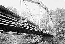
- Old Normans Kill Bridge – Original bridge across the Normans Kill, over 60 feet below the current Normanskill Viaduct.[11] The bridge, built in 1884, is 158 feet long, paved with yellow bricks, and barely wide enough for two cars to pass.[10] Local legend states that Edgar Allan Poe wrote about the yellow bricks the road and bridge were paved with and this was picked up by L. Frank Baum who used this reference in The Wonderful Wizard of Oz. Local historians stress this has not been confirmed and is just local lore.[11][16] The bridge has been closed to vehicular traffic since 1990.
See also
References
- 1 2 George Howell and Jonathan Tenney (1886). Bi-Centennial History of Albany: History of the County of Albany from 1609-1886; Volume 2. W.W. Munsell and Company. p. 790. Retrieved 2010-02-10.
- 1 2 3 4 5 George Howell and Jonathan Tenney (1886). Bi-Centennial History of Albany: History of the County of Albany from 1609-1886; Volume 2. W.W. Munsell and Company. pp. 781–2. Retrieved 2010-02-10.
- ↑ "Town of Bethlehem, NY History". Town of Bethlehem. Archived from the original on November 21, 2009. Retrieved 2010-02-25.
- ↑ Leath, Susan (2016). Historic Tales of Bethlehem, New York. The History Press. p. 144. ISBN 9781467118552.
- ↑ William V.R. Erving (1920). Department Reports of the State of New York Containing the Messages of the Governor and the Decisions, Opinions and Rulings of the State Officers, Departments, Boards and Commissions; Volume 22. J.B. Lyon Company. pp. 300–301. Retrieved 2010-02-28.
- ↑ Julie Carr (April 6, 1994). "Trees and Faces Both Fall Over Bridge Construction". Albany Times Union. p. B3. Retrieved 2010-02-28.
- ↑ Barbara Hayden (September 24, 1989). "Normansville Resident Charts Past Hamlet Once Thriving Center of Homes, Commerce". Albany Times Union. p. B10. Retrieved 2010-02-28.
- ↑ "Normansville Group Against Span Reopening". Albany Times Union. October 28, 1987. p. 6A. Retrieved 2010-02-28.
- ↑ Christopher Ringwald (July 10, 1996). "The Current Slows in Normansville". Albany Times Union. p. B1. Retrieved 2010-02-38. Check date values in:
|accessdate=(help) - 1 2 Barbara Hayden (February 17, 1990). "History or Economy Closed Bridge a Sore Spot in Normansville". Albany Times Union. p. B6. Retrieved 2010-02-28.
- 1 2 3 4 Rick Karlin (April 18, 1993). "A Bridges Moves Atop Tiny Normansville". Albany Times Union. p. H1. Retrieved 2010-02-28.
- ↑ Deborah Gesensway (May 9, 1988). "Albany Grows on City Farmers". Albany Times Union. p. A1. Retrieved 2010-02-28.
- ↑ Brian Nearing (August 6, 2004). "Old Iron Bridge Showing its Age". Albany Times Union. p. B1. Retrieved 2010-02-28.
- ↑ Frances Ingraham (September 22, 2002). "Riding the Beat Albany's Mounted Police Form a Special Bond With Their Equine Partners". Albany Times Union. p. G1. Retrieved 2010-02-28.
- ↑ "Lake to be Drained to Fix Sewer Line". Albany Times Union. November 18, 1995. p. B4. Retrieved 2010-02-28.
- ↑ Rick Karlin (July 6, 1995). "Bridge Legends Run Deep and Wide". Albany Times Union. p. C1. Retrieved 2010-02-28.
Further reading
- Michael Lisa (June 21, 2009). "Neighborhoods: Normansville, Bethlehem". Albany Times Union. p.G7.
- Dawn Padfield (September 1, 2009). "The Yellow Brick Road". All Over Albany (Uptown/Downtown Media).
Municipalities and communities of Albany County, New York, United States | ||
|---|---|---|
| Cities |  | |
| Towns | ||
| Villages | ||
| CDPs | ||
| Other hamlets |
| |