Viroinval
- Nismes redirects here. The French municipality of which the name sounds alike, is Nîmes.
| Viroinval | |||
|---|---|---|---|
| Municipality | |||
 | |||
| |||
 Viroinval Location in Belgium
Location of Viroinval in the province of Namur 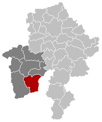 | |||
| Coordinates: 50°05′N 04°33′E / 50.083°N 4.550°ECoordinates: 50°05′N 04°33′E / 50.083°N 4.550°E | |||
| Country | Belgium | ||
| Community | French Community | ||
| Region | Wallonia | ||
| Province | Namur | ||
| Arrondissement | Philippeville | ||
| Government | |||
| • Mayor | Freddy Cabaraux (PS) | ||
| • Governing party/ies | PS, CDH | ||
| Area | |||
| • Total | 120.90 km2 (46.68 sq mi) | ||
| Population (1 January 2017)[1] | |||
| • Total | 5,755 | ||
| • Density | 48/km2 (120/sq mi) | ||
| Postal codes | 5670 | ||
| Area codes | 060 | ||
| Website | www.viroinval.be | ||


Viroinval (French pronunciation: [viʁwɛ̃val], Walloon: Virwinvå) is a Walloon municipality located in Belgium in the province of Namur. On January 1, 2006 Viroinval had a total population of 5,680. The total area is 120.90 km² which gives a population density of 47 inhabitants per km².
Villages in Viroinval
The name Viroinval, Viroin (River) Valley, was chosen for the municipality that was formed by fusing eight villages, in 1977: Dourbes, Mazée, Le Mesnil, Nismes, Oignies-en-Thiérache, Olloy-sur-Viroin, Treignes, Vierves-sur-Viroin.[2]
 Dourbes
 Nismes
.JPG) Olloy-sur-Viroin
Olloy-sur-Viroin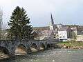 Treignes
- Vierves-sur-Viroin
Attractions
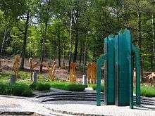
Monument for the geographical centre of the EU until its May 2004 expansion
- From 1995 to 2004, Viroinval was the location of the geographical centre of the European Union, at coordinates 50°00′33″N 4°39′59″E / 50.00917°N 4.66639°E in Oignies-en-Thiérache, and a monument there records that finding. On May 1, 2004 the EU expanded from fifteen states to twenty-five, and the geographical centre of the union moved eastwards to the village of Kleinmaischeid, Rhineland-Palatinate, Germany. On 1 January 2007 it shifted even further south-eastwards.
- The tourist steam train line Mariembourg–Treignes has most of its stations in villages of Viroinval: Nismes, Olloy-sur-Viroin, Vierves-sur-Viroin, and Treignes.[3] The latter village has a relevant museum.[4]
References
- ↑ Population per municipality as of 1 January 2017 (XLS; 397 KB)
- ↑ "Viroinval" (in French). Viroinval municipality. Retrieved 2011-09-24.
- ↑ "Trois Vallées – Chemin de fer touristique" (in French). Viroinval municipality. Retrieved 2011-09-24.
- ↑ "Musée du Chemin de Fer à Vapeur des Trois Vallées" (in French). Viroinval municipality. Retrieved 2011-09-24.
External links
| Wikimedia Commons has media related to Viroinval. |
- Official Website of the municipality
- The former Centre of the European Union
- Awarded "EDEN - European Destinations of Excellence" non traditional tourist destination 2009
Places adjacent to Viroinval | |
|---|---|
Municipalities in the Province of Namur | ||
|---|---|---|
| Dinant | 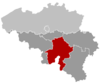 | |
| Namur | ||
| Philippeville | ||
This article is issued from
Wikipedia.
The text is licensed under Creative Commons - Attribution - Sharealike.
Additional terms may apply for the media files.