Jemeppe-sur-Sambre
| Jemeppe-sur-Sambre | ||
|---|---|---|
| Municipality | ||
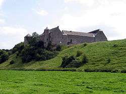 Balâtre Castle | ||
| ||
 Jemeppe-sur-Sambre Location in Belgium
Location of Jemeppe-sur-Sambre in the province of Namur 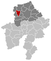 | ||
| Coordinates: 50°28′N 04°40′E / 50.467°N 4.667°ECoordinates: 50°28′N 04°40′E / 50.467°N 4.667°E | ||
| Country | Belgium | |
| Community | French Community | |
| Region | Wallonia | |
| Province | Namur | |
| Arrondissement | Namur | |
| Government | ||
| • Mayor | Stéphanie Thoron | |
| • Governing party/ies | MR - cdH - Ecolo - SEL | |
| Area | ||
| • Total | 46.80 km2 (18.07 sq mi) | |
| Population (1 January 2017)[1] | ||
| • Total | 18,998 | |
| • Density | 410/km2 (1,100/sq mi) | |
| Postal codes | 5190 | |
| Area codes | 071 | |
| Website | www.jemeppe-sur-sambre.be | |

Jemeppe-sur-Sambre (French: [ʒə.mɛp.syʁ.sɑ̃bʁ]) is a Walloon municipality located in the Belgian province of Namur. On 1 January 2006 the municipality had 17,990 inhabitants. The total area is 46.80 km², giving a population density of 384 inhabitants per km².
Apart from the village of Jemeppe-sur-Sambre itself, the municipality contains the localities of Ham-sur-Sambre, Moustier-sur-Sambre, Spy, Mornimont, Balâtre, Onoz, and Saint-Martin.
The Grotte de Spy is located in the municipality near the village of Spy. The medieval Balâtre Castle is in the village of Balâtre, and Mielmont Castle in Onoz.
See also
References
- ↑ Population per municipality as of 1 January 2017 (XLS; 397 KB)
External links

- Official website (in French)
Places adjacent to Jemeppe-sur-Sambre | ||||||||||
|---|---|---|---|---|---|---|---|---|---|---|
| ||||||||||
Municipalities in the Province of Namur | ||
|---|---|---|
| Dinant | 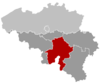 | |
| Namur | ||
| Philippeville | ||
This article is issued from
Wikipedia.
The text is licensed under Creative Commons - Attribution - Sharealike.
Additional terms may apply for the media files.