Floreffe
| Floreffe | ||
|---|---|---|
| Municipality | ||
.JPG) | ||
| ||
 Floreffe Location in Belgium
Location of Floreffe in the province of Namur 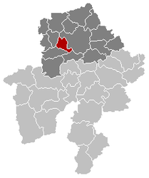 | ||
| Coordinates: 50°26′N 04°47′E / 50.433°N 4.783°ECoordinates: 50°26′N 04°47′E / 50.433°N 4.783°E | ||
| Country | Belgium | |
| Community | French Community | |
| Region | Wallonia | |
| Province | Namur | |
| Arrondissement | Namur | |
| Government | ||
| • Mayor | André Bodson (RPF) | |
| • Governing party/ies | RPF | |
| Area | ||
| • Total | 38.89 km2 (15.02 sq mi) | |
| Population (1 January 2017)[1] | ||
| • Total | 8,051 | |
| • Density | 210/km2 (540/sq mi) | |
| Postal codes | 5150 | |
| Area codes | 081 | |
| Website | www.floreffe.be | |

Floreffe (French pronunciation: [flɔ.ʁɛf]; Walloon: Florefe) is a Walloon municipality located in the Belgian province of Namur. On 1 January 2012 the municipality had 7,883 inhabitants. The total area is 38.89 km², giving a population density of 203 inhabitants per km².
The municipality consists of the following sub-municipalities: Floreffe proper, Floriffoux, Franière, and Soye.
Floreffe is best known as the location of Floreffe Abbey, founded in the 12th century and suppressed during the French Revolution.
Twin towns

See also
References
- ↑ Population per municipality as of 1 January 2017 (XLS; 397 KB)
External links

- Official website (in French)
Places adjacent to Floreffe | |
|---|---|
Municipalities in the Province of Namur | ||
|---|---|---|
| Dinant | 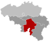 | |
| Namur | ||
| Philippeville | ||
This article is issued from
Wikipedia.
The text is licensed under Creative Commons - Attribution - Sharealike.
Additional terms may apply for the media files.