Nishikyō-ku, Kyoto
| Nishikyō 西京区 | |
|---|---|
| Ward of Kyoto | |
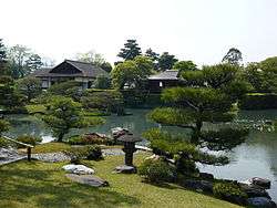 Katsura Imperial Villa | |
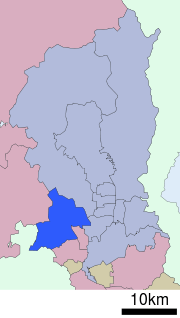 Location of Nishikyō-ku in Kyoto | |
 Nishikyō Location of Nishikyō-ku in Japan | |
| Coordinates: 34°59′6″N 135°41′36″E / 34.98500°N 135.69333°ECoordinates: 34°59′6″N 135°41′36″E / 34.98500°N 135.69333°E | |
| Founded | 1976 |
| Area | |
| • Total | 59.24 km2 (22.87 sq mi) |
| Highest elevation | 678 m (2,224 ft) |
| Lowest elevation | 18 m (59 ft) |
| Population (October 1, 2015) | |
| • Total | 150,962 |
| • Estimate (2016) | 150,477 |
| • Density | 2,500/km2 (6,600/sq mi) |
| Time zone | UTC+9 (Japan Standard Time) |
| Website |
www |
Nishikyō-ku (西京区) is one of the eleven wards in the city of Kyoto, in Kyoto Prefecture, Japan. Its name means "west capital ward" and it is situated on the western edge of the city, to the south of center. The ward was established on October 1, 1976, after it was separated from Ukyō-ku. The Katsura River is the border between Nishikyo-ku and Ukyo-ku.
Katsura Imperial Villa, on that river, is one of the most widely known features of Nishikyo-ku. Saihō-ji, the Moss Temple, is a UNESCO World Heritage Site in the ward.
Matsunoo-taisha, a Shinto shrine, is also located in Nishikyō-ku.
As of October 1, 2016 the ward has an area of 59.24 km² and a population of 150,477.
Demographics
| Historical population | ||
|---|---|---|
| Year | Pop. | ±% |
| 1980 | 109,325 | — |
| 1990 | 142,677 | +30.5% |
| 2000 | 155,928 | +9.3% |
| 2010 | 152,974 | −1.9% |
| 2015 | 150,962 | −1.3% |
| Source: | ||
Education

International Research Center for Japanese Studies
External links
![]()
- Official website (in Japanese)
This article is issued from
Wikipedia.
The text is licensed under Creative Commons - Attribution - Sharealike.
Additional terms may apply for the media files.