Ine, Kyoto
| Ine 伊根町 | |||
|---|---|---|---|
| Town | |||
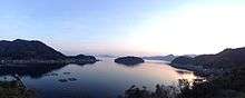 View of Ine | |||
| |||
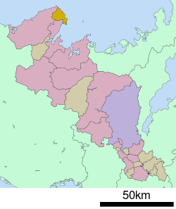 Location of Ine in Kyoto Prefecture | |||
 Ine Location in Japan | |||
| Coordinates: 35°41′N 135°17′E / 35.683°N 135.283°ECoordinates: 35°41′N 135°17′E / 35.683°N 135.283°E | |||
| Country | Japan | ||
| Region | Kansai | ||
| Prefecture | Kyoto Prefecture | ||
| District | Yosa | ||
| Government | |||
| • Mayor | Yoshimoto Hideki | ||
| Area | |||
| • Total | 61.95 km2 (23.92 sq mi) | ||
| Population (October 1, 2017) | |||
| • Total | 1,986 | ||
| • Density | 32/km2 (83/sq mi) | ||
| Symbols | |||
| • Tree | Japanese Black Pine | ||
| • Flower | Chrysanthemum | ||
| Time zone | UTC+9 (JST) | ||
| Website |
www | ||


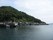
Ine (伊根町 Ine-chō) is a town located in Yosa District, Kyoto Prefecture, Japan. It is famous for wooden fishing houses called "Funaya", selected as Groups of Traditional Buildings.
The Tango Peninsula was a trade route from Eurasian Continent to Kyoto. Fishing and sightseeing are main industries now.
Tsutsukawa district and Honjo-Hama district have been handed down Urashima Tarō legend. Nii district has a legend of Xu Fu(Jofuku in Japanese).
As of October 2017, the town has an estimated population of 1,986.[1] The total area is 61.95 km².
History
July 30, 1945, United States air-raided Ine.
November 3, 1954, Ine was founded by the merger of four villages.
- Asadsuma village(朝妻村)
- Ine village(伊根村)
- Tsutsukawa village(筒川村)
- Honjo Village(本庄村)
October 3, 1955, song of town and symbol of town were enacted.
January 1974, pine was selected as tree of town.
1993, Eenyobo(ええにょぼ)(Asadora) was on TV which was set in Funaya of Ine town.
April 11, 2005, town office moved from Hirata to present place. July 22, Ine bay(伊根湾) was selected as Groups of Traditional Buildings for the first time in a fishing village.
December 2, 2007, Yoro-Ine Bypass (Japan National Route 178) opened. 2nd traffic light in Ine town was made.
October 2008, Ine town joined The Most Beautiful Villages in Japan.
Geography
Located on the coast of the Sea of Japan on the northeast side of the Tango Peninsula in the northwestern corner of the prefecture.
- Northeast~Southeast: Wakasa bay(若狭湾)(Sea of Japan)
- South: Miyazu, Kyoto
- West: Kyōtango
Population
- 1970…4,779
- 1975…4,283
- 1980…4,021
- 1985…3,792
- 1990…3,586
- 1995…3,361
- 2000…3,112
- 2005…2,718
- 2010…2,410
- 2015…2,110
Politics and government
Ine is governed by mayor Yoshimoto Hideki, an independent. The city assembly has 10 members.
Industry
Industrial population
- All of employed: 1,334
- The primary industry: 412
- The secondary industry: 213
- The tertiary industry: 707
Fishery
Total annual a catch is 3,190 tons, accounting for 25 percent of all catch in Kyoto Prefecture.
Transportation
Bus
- Tankai Bus
- Ine Line
- Kamanyu Line
- Kyōgamisaki Line
- The municipal Bus
Ports
- The Ine sea route
Tourism
- Funaya of Ine
- The spa of Oku-Ine
- Urashima Park
- The Urashima shrine (Ura Shrine)
Movie
References
- ↑ "Official website of Kyoto Prefecture" (in Japanese). Japan: Kyoto Prefecture. Retrieved 11 February 2018.
External links
![]()
- Ine official website (in Japanese)