Nikolaevsk, Alaska
| Nikolaevsk, Alaska | |
|---|---|
| CDP | |
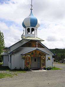 Russian Old Believers Church in Nikolaevsk | |
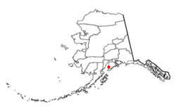 Location of Nikolaevsk, Alaska | |
| Coordinates: 59°48′43″N 151°36′36″W / 59.81194°N 151.61000°WCoordinates: 59°48′43″N 151°36′36″W / 59.81194°N 151.61000°W | |
| Country | United States |
| State | Alaska |
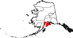
| Borough | Kenai Peninsula |
| Government | |
| • Borough mayor | Mike Navarre[1] |
| • State senator | Gary Stevens (R) |
| • State rep. | Paul Seaton (R) |
| Area | |
| • Total | 36.3 sq mi (93.9 km2) |
| • Land | 36.3 sq mi (93.9 km2) |
| • Water | 0.0 sq mi (0.0 km2) |
| Elevation | 840 ft (256 m) |
| Population (2010) | |
| • Total | 318 |
| • Density | 9.5/sq mi (3.7/km2) |
| Time zone | UTC-9 (Alaska (AKST)) |
| • Summer (DST) | UTC-8 (AKDT) |
| ZIP code | 99556 |
| Area code(s) | 907 |
| FIPS code | 02-54085 |
| GNIS feature ID | 1417063 |
Nikolaevsk (Russian: Николаевск) is a census-designated place (CDP) in Kenai Peninsula Borough in the U.S. state of Alaska. As of the 2010 census, the population of the CDP is 318, down from 345 in 2000. Nikolaevsk School serves school-age children from the area.
History
The town was settled by a group of Old Believers of the Russian Orthodox Old-Rite Church around 1968, and remains a largely ethnic Russian town to this day.[2] The travels of the group from Russia, as well as the story of the founding of Nikolaevsk, is told in a 1972 article in National Geographic,[3] a 2013 episode on the NatGeo channel called 'Red Alaska', and a 2013 article in The Atlantic magazine. [4]
Geography
Nikolaevsk is located at 59°48′47″N 151°40′6″W / 59.81306°N 151.66833°W (59.813043, -151.668387).[5]
According to the United States Census Bureau, the CDP has a total area of 36.3 square miles (94 km2), all of it land. Road access is via the North Fork Road, which junctions with the Sterling Highway 9 miles (14 km) away in Anchor Point.[6]
Demographics
| Historical population | |||
|---|---|---|---|
| Census | Pop. | %± | |
| 1990 | 371 | — | |
| 2000 | 345 | −7.0% | |
| 2010 | 318 | −7.8% | |
| U.S. Decennial Census[7] | |||
Nikolaevsk first reported on the 1990 U.S. Census as a census-designated place (CDP).
| Largest ancestries (2000) [8] | Percent |
|---|---|
| Russian | 67.5% |
| German | 7.5% |
| English | 7.2% |
| Irish | 3.6% |
| French | 2.6% |
| Dutch | 1.0% |
| Hungarian | 1.0% |
| Swedish | 1.0% |
| American | 1.0% |
| Languages (2000) [9] | Percent |
|---|---|
| Spoke Russian at home | 66.57% |
| Spoke English at home | 33.43% |
| Spoke English "not well" or "not at all." | 5.52% |
As of the census[10] of 2000, there were 345 people, 96 households, and 72 families residing in the CDP. The population density was 9.5 people per square mile (3.7/km²). There were 122 housing units at an average density of 3.4/sq mi (1.3/km²). The racial makeup of the CDP was 81.74% Russian, 1.74% Native American, 0.29% Asian, 1.16% Pacific Islander, 2.03% from other races, and 13.04% from two or more races. 0.29% of the population were Hispanic or Latino of any race.
Out of the 96 households, 57.3% had children under the age of 18 living with them, 65.6% were married couples living together, 5.2% had a female householder with no husband present, and 24.0% were non-families. 18.8% of all households were made up of individuals and 2.1% had someone living alone who was 65 years of age or older. The average household size was 3.59 and the average family size was 4.33.
In the CDP, the population was spread out with 45.2% under the age of 18, 7.8% from 18 to 24, 26.4% from 25 to 44, 17.1% from 45 to 64, and 3.5% who were 65 years of age or older. The median age was 21 years. For every 100 females, there were 104.1 males. For every 100 females age 18 and over, there were 119.8 males.
The median income for a household in the CDP was $37,500, and the median income for a family was $39,375. Males had a median income of $26,250 versus $25,833 for females. The per capita income for the CDP was $10,390. About 15.8% of families and 19.2% of the population were below the poverty line, including 20.9% of those under age 18 and 16.7% of those age 65 or over.
References
- ↑ 2015 Alaska Municipal Officials Directory. Juneau: Alaska Municipal League. 2015. p. 9.
- ↑ Vitaliev, Vitali. (n.d.) Old Believers in Alaska, Travelintelligence.com. Retrieved November 9, 2009
- ↑ Rearden, Jim. (September 1972). A Bit of Old Russia Takes Root in Alaska. National Geographic, 142:3, 401–424
- ↑ Wendi Jonassen and Ryan Loughlin A 17th-Century Russian Community Living in 21st-Century Alaska Retrieved July 8, 2017
- ↑ "US Gazetteer files: 2010, 2000, and 1990". United States Census Bureau. February 12, 2011. Retrieved April 23, 2011.
- ↑ The Milepost, 59th edition, page 635, ISBN 978-1-892154-21-7
- ↑ "U.S. Decennial Census". Census.gov. Retrieved June 6, 2013.
- ↑ "American Factfinder, Community Facts, Nikolaevsk, Alaska, Origins and Language, Census 2000, Selected Social Characteristics (Household and Family Type, Disability, Citizenship, Ancestry, Language, ...)". U.S. Census Bureau. Retrieved October 18, 2016.
- ↑ https://apps.mla.org/map_data_results&SRVY_YEAR=2000&geo=&state_id=2&county_id=&mode=place&lang_id=&zip=&place_id=54085&cty_id=®ion_id=&division_id=&ll=&ea=y&order=&a=y&pc=1
- ↑ "American FactFinder". United States Census Bureau. Archived from the original on September 11, 2013. Retrieved January 31, 2008.