Tyonek, Alaska
| Tyonek, Alaska | |
|---|---|
| CDP | |
 Location of Tyonek, Alaska | |
| Coordinates: 61°04′05″N 151°08′28″W / 61.068°N 151.141°WCoordinates: 61°04′05″N 151°08′28″W / 61.068°N 151.141°W | |
| Country | United States |
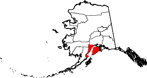
| State | Alaska |
| Borough | Kenai Peninsula |
| Government | |
| • Borough mayor | Mike Navarre[1] |
| • State senator | Gary Stevens (R) |
| • State rep. | Louise Stutes (R) |
| Area | |
| • Total | 68.8 sq mi (178.2 km2) |
| • Land | 67.6 sq mi (175.1 km2) |
| • Water | 1.2 sq mi (3.1 km2) |
| Population (2010) | |
| • Total | 171 |
| • Density | 2.9/sq mi (1.1/km2) |
| Time zone | UTC-9 (Alaska (AKST)) |
| • Summer (DST) | UTC-8 (AKDT) |
| ZIP code | 99682 |
| Area code(s) | 907 |
| FIPS code | 02-79890 |
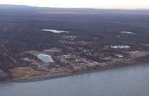
Tyonek (Dena'ina: Qaggeyshlat) is a census-designated place (CDP) in Kenai Peninsula Borough in the U.S. state of Alaska. As of the 2010 census the population was 171, down from 193 in 2000. In 1973, Tyonek formed Tyonek Native Corporation (TNC) under ANCSA and is federally recognized.
History
A Dena'ina Alaska Native village at Tyonek was noted by the explorer James Cook in 1778. The Lebedev-Lastochkin Company, a Russian fur trade venture, maintained a small trapping station on the site of Tyonek.[2] A detachment of the Vancouver Expedition under Joseph Whidbey visited the trading post in May 1794. Whidbey found that the LLC maintained "one large house, about fifty feet long, twenty-four wide, and about ten feet high; this was appropriated to the residence of nineteen Russians..."[3] A smallpox epidemic in the late 1830s killed about half the population. Tyonek became a major port during the Resurrection Creek gold rush of the 1880s, but declined after the founding of Anchorage on the other side of Cook Inlet in 1915. Tyonek was moved to its current site when the original village, located on lower ground, flooded in the 1930s.
Geography
Tyonek is located at 61°3′38″N 151°13′51″W / 61.06056°N 151.23083°W (61.060470, -151.230697).[4]
According to the United States Census Bureau, the CDP has a total area of 68.8 square miles (178 km2), of which, 67.6 square miles (175 km2) of it is land and 1.2 square miles (3.1 km2) of it (1.73%) is water. Although politically in the Kenai Peninsula Borough, it is located on the mainland on the opposite side of Cook Inlet from the peninsula.
Demographics
| Historical population | |||
|---|---|---|---|
| Census | Pop. | %± | |
| 1880 | 117 | — | |
| 1890 | 115 | −1.7% | |
| 1900 | 107 | −7.0% | |
| 1920 | 58 | — | |
| 1930 | 78 | 34.5% | |
| 1940 | 136 | 74.4% | |
| 1950 | 132 | −2.9% | |
| 1960 | 187 | 41.7% | |
| 1970 | 232 | 24.1% | |
| 1980 | 239 | 3.0% | |
| 1990 | 154 | −35.6% | |
| 2000 | 193 | 25.3% | |
| 2010 | 171 | −11.4% | |
| U.S. Decennial Census[5] | |||
Tyonek first appeared on the 1880 U.S. Census as the unincorporated Tinneh village of "Toyonok Station and Village." It featured 117 residents, including 109 Tinneh, 6 Creole (Mixed Russian & Native) and 2 Whites.[6][7] This settlement was initially located at Beshta Bay. It returned again as "Toyonok" in 1890 with 115 residents, all Native.[8] In 1900, it returned as Tyonek. It did not report on the 1910 census. It returned again in 1920. In 1930, it reported 78 residents, of which 74 were Native and 4 were White.[9]
In the early 1930s, residents began to relocate 7 miles northeast to a new site, the "new" Tyonek, situated on higher ground because of flooding.[10] The original site became known as "Old Tyonek." Beginning with the 1940 census, the figures reflected the "new" Tyonek. Old Tyonek did not report separately again. The present Tyonek was made a census-designated place (CDP) in 1980. The boundaries of the CDP now include the original (old) Tyonek.[11]
As of the census[12] of 2000, there were 193 people, 66 households, and 45 families residing in the CDP. The population density was 2.9 people per square mile (1.1/km²). There were 134 housing units at an average density of 2.0/sq mi (0.8/km²). The racial makeup of the CDP was 4.66% White and 95.34% Native American. 2.59% of the population were Hispanic or Latino of any race.
There were 66 households out of which 42.4% had children under the age of 18 living with them, 27.3% were married couples living together, 22.7% had a female householder with no husband present, and 31.8% were non-families. 30.3% of all households were made up of individuals and 7.6% had someone living alone who was 65 years of age or older. The average household size was 2.92 and the average family size was 3.42.
In the CDP, the population was spread out with 37.3% under the age of 18, 6.7% from 18 to 24, 33.7% from 25 to 44, 17.1% from 45 to 64, and 5.2% who were 65 years of age or older. The median age was 28 years. For every 100 females, there were 124.4 males. For every 100 females age 18 and over, there were 128.3 males.
The median income for a household in the CDP was $26,667, and the median income for a family was $29,792. Males had a median income of $26,250 versus $26,250 for females. The per capita income for the CDP was $11,261. About 2.1% of families and 13.9% of the population were below the poverty line, including none of those under the age of eighteen or sixty five or over.
References
- ↑ 2015 Alaska Municipal Officials Directory. Juneau: Alaska Municipal League. 2015. p. 9.
- ↑ Solojova, Katerina and Aleksandra Vovnyanko. The Rise and Decline of the Lebedev-Lastochkin Company: Russian Colonization of South Central Alaska, 1787-1798. The Pacific Northwest Quarterly 90, No. 4 (1999), pp. 191-205.
- ↑ Vancouver, George A voyage of discovery to the North Pacific Ocean... Vol. 3. London: J. Edwards Pall Mall and G. Robinson Paternoster Row. 1798, p. 122.
- ↑ "US Gazetteer files: 2010, 2000, and 1990". United States Census Bureau. 2011-02-12. Retrieved 2011-04-23.
- ↑ "U.S. Decennial Census". Census.gov. Retrieved June 6, 2013.
- ↑ https://books.google.com/books?id=Rr9RAQAAMAAJ&pg=PA49&lpg=PA49&dq=%22Agaligamute%22&source=bl&ots=Tzy-F6Dup7&sig=B81GmrTlcKv3jtL_iWMYTwV3FSo&hl=en&sa=X&ved=0ahUKEwj69sDB-MLUAhXD2T4KHTt1Dc0Q6AEILjAD#v=onepage&q=tyonek&f=false
- ↑ http://www2.census.gov/prod2/decennial/documents/1880a_v1-17.pdf
- ↑ http://www2.census.gov/prod2/decennial/documents/1890a_v8-01.pdf
- ↑ http://akgenweb.com/census/censuspdfs/1930AK3rdDistrictPartC.pdf
- ↑ https://books.google.com/books?id=YtwUBQAAQBAJ&pg=PA274&lpg=PA274&dq=%22Knakatnuk%22+%22alaska%22&source=bl&ots=M5w1-gZqP0&sig=casDuhA8Y_Dbhez665xgYxUMQKU&hl=en&sa=X&ved=0ahUKEwiF7-qf3cnZAhVE6VMKHVTfDjkQ6AEIPjAH#v=snippet&q=new%20tyonek&f=false
- ↑ http://live.laborstats.alaska.gov/cen/maps/place/2010/79890.pdf
- ↑ "American FactFinder". United States Census Bureau. Retrieved 2008-01-31.