Primrose, Alaska
| Primrose, Alaska | |
|---|---|
| CDP | |
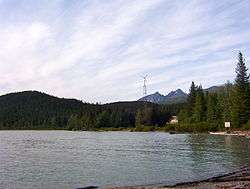 Primrose waterfront seen from Chugach National Forest campground | |
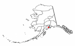 Location of Primrose, Alaska | |
| Coordinates: 60°20′36″N 149°20′39″W / 60.34333°N 149.34417°WCoordinates: 60°20′36″N 149°20′39″W / 60.34333°N 149.34417°W | |
| Country | United States |
| State | Alaska |
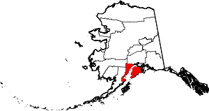
| Borough | Kenai Peninsula |
| Government | |
| • Borough mayor | Mike Navarre[1] |
| • State senator | Peter Micciche (R) |
| • State rep. | Mike Chenault (R) |
| Area | |
| • Total | 38.4 sq mi (99.4 km2) |
| • Land | 37.4 sq mi (96.9 km2) |
| • Water | 1.0 sq mi (2.5 km2) |
| Elevation | 3,212 ft (979 m) |
| Population (2000) | |
| • Total | 93 |
| • Density | 2.5/sq mi (1.0/km2) |
| Time zone | UTC-9 (Alaska (AKST)) |
| • Summer (DST) | UTC-8 (AKDT) |
| Area code(s) | 907 |
| FIPS code | 02-64240 |
| GNIS feature ID | 1866971 |
Primrose is a census-designated place (CDP) in Kenai Peninsula Borough, Alaska, United States. The population was 93 at the 2000 census and 78 at the 2010 census. Primrose is one of a number of small communities located north of Seward alongside the Seward Highway.
Geography
Primrose is located at 60°20′36″N 149°20′39″W / 60.34333°N 149.34417°W (60.343405, -149.344250),[2] at the confluence of the Snow River and Kenai Lake.
According to the United States Census Bureau, the CDP has a total area of 38.4 square miles (99 km2), of which, 37.4 square miles (97 km2) of it is land and 1.0 square mile (2.6 km2) of it (2.53%) is water.
Demographics
| Historical population | |||
|---|---|---|---|
| Census | Pop. | %± | |
| 1990 | 63 | — | |
| 2000 | 93 | 47.6% | |
| 2010 | 78 | −16.1% | |
Primrose first appeared on the 1990 U.S. Census as a census-designated place (CDP).
As of the 2000 census,[3] there were 93 people, 33 households, and 29 families residing in the CDP. The population density was 2.5 people per square mile (1.0/km²). There were 47 housing units at an average density of 1.3/sq mi (0.5/km²). The racial makeup of the CDP was 91.40% White, 3.23% Native American, 1.08% Asian, 1.08% Pacific Islander, and 3.23% from two or more races.
There were 33 households out of which 42.4% had children under the age of 18 living with them, 75.8% were married couples living together, 6.1% had a female householder with no husband present, and 12.1% were non-families. 9.1% of all households were made up of individuals and none had someone living alone who was 65 years of age or older. The average household size was 2.82 and the average family size was 3.00.
In the CDP, the population was spread out with 34.4% under the age of 18, 1.1% from 18 to 24, 24.7% from 25 to 44, 28.0% from 45 to 64, and 11.8% who were 65 years of age or older. The median age was 42 years. For every 100 females, there were 93.8 males. For every 100 females age 18 and over, there were 96.8 males.
The median income for a household in the CDP was $66,111, and the median income for a family was $66,944. Males had a median income of $48,472 versus $0 for females. The per capita income for the CDP was $18,904. None of the population and none of the families were below the poverty line.
References
- ↑ 2015 Alaska Municipal Officials Directory. Juneau: Alaska Municipal League. 2015. p. 9.
- ↑ "US Gazetteer files: 2010, 2000, and 1990". United States Census Bureau. 2011-02-12. Retrieved 2011-04-23.
- ↑ "American FactFinder". United States Census Bureau. Retrieved 2008-01-31.