Sterling Highway
| |
|---|---|
| Route information | |
| Length | 138 mi[1] (222 km) |
| Existed | 1950–present |
| Major junctions | |
| West end |
|
| East end |
|
| Highway system | |

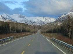
The Sterling Highway is a 138-mile-long (222 km) state highway in the south-central region of the U.S. state of Alaska, leading from the Seward Highway at Tern Lake Junction, 90 miles (140 km) south of Anchorage, to Homer.
Route description
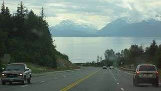
It is part of Alaska Route 1. It leads mainly west from Tern Lake to Soldotna, paralleling the Kenai River, at which point it turns south to follow the eastern shore of Cook Inlet. It is the only highway in the western and central Kenai Peninsula, and most of the population of the Kenai Peninsula Borough lives near it. The highway also gives access to many extremely popular fishing and recreation areas, including the Chugach National Forest, Kenai National Wildlife Refuge, and the Kenai, Funny, and Russian rivers. The southern end of the highway is at the tip of the Homer Spit, a sandbar extending 4.5 miles (7.2 km) into Kachemak Bay. A ferry terminal here connects the road to the Alaska Marine Highway.[1]
Mileposts along the Sterling Highway do not begin with zero. Instead, they begin with Mile 37 (60 km), continuing the milepost numbering of the Seward Highway where the two highways intersect near Tern Lake. The 0 (zero) mile marker for the Seward Highway is at its terminus in downtown Seward at the intersection of 3rd Avenue and Railway Avenue. Thus, mileposts along the Sterling Highway reflect distance from Seward, which is not actually on the Sterling Highway.
History
Construction of the highway began in 1947 and was completed in 1950.
Interstate Highway System
| |
|---|---|
| Location | Soldotna to Anchorage |
| Length | 238.38 mi (383.64 km) |
| Existed | 1976–present |

George Parks Highway is part of the unsigned part of the Interstate Highway System as Interstate A-3.[2][3]
Major intersections
The entire route is in Kenai Peninsula Borough.
| Location | mi | km | Destinations | Notes | |
|---|---|---|---|---|---|
| Homer | Western terminus | ||||
| Tern Lake Junction | Eastern terminus | ||||
| 1.000 mi = 1.609 km; 1.000 km = 0.621 mi | |||||
References
Route map:
- 1 2 Google (December 28, 2013). "Sterling Highway" (Map). Google Maps. Google. Retrieved December 28, 2013.
- ↑ Federal Highway Administration, National Highway System Viewer Archived 2007-08-27 at the Wayback Machine.. Retrieved August 2007.
- ↑ Alaska Department of Transportation and Public Facilities, Dwight D. Eisenhower Interstate Routes Archived 2009-07-27 at the Wayback Machine., April 2006