Newport, Isle of Wight
| Newport | |
|---|---|
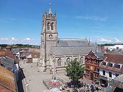 St Thomas' Church, set within St Thomas's Square | |
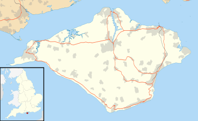 Newport Newport shown within the Isle of Wight | |
| Area | 54.4439 km2 (21.0209 sq mi) [1] |
| Population | 25,496 (2011) |
| • Density | 468/km2 (1,210/sq mi) |
| OS grid reference | SZ502893 |
| • London | 90.26 miles |
| Civil parish |
|
| Unitary authority | |
| Ceremonial county | |
| Region | |
| Country | England |
| Sovereign state | United Kingdom |
| Post town | NEWPORT |
| Postcode district | PO30 |
| Dialling code | 01983 |
| Police | Hampshire |
| Fire | Isle of Wight |
| Ambulance | Isle of Wight |
| EU Parliament | South East England |
| UK Parliament | |
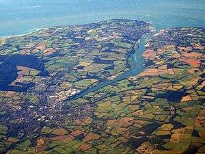
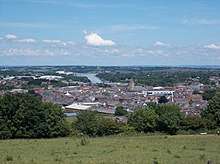
Newport is a civil parish and the county town of the Isle of Wight, an island off the south coast of England. The civil parish had a population of 23,957 at the time of the 2001 census, which rose to 25,496 at the 2011 census.[2] The town lies slightly to the north of the centre of the Island. It has a quay at the head of the navigable section of the River Medina, which flows northward to Cowes and the Solent.
History
Mousterian remains, featuring tools made by Neanderthals at least 40,000 years ago, were found at Great Pan Farm in the 1970s.[3]
There are signs of Roman settlement in the area, which was probably known as Medina, including two known Roman villas, one of which, Newport Roman Villa, has been excavated and is open to the public.[4]
Information about the area resumes after the Norman Conquest. The first charter was granted in the late 12th century. In 1377 an invading French force burnt down much of the town while attempting to take Carisbrooke Castle, then under the command of Sir Hugh Tyrill. A group of Frenchmen were captured and killed, then buried in a tumulus later nicknamed Noddies Hill, a "noddy" being medieval slang for a body. This was later corrupted to Nodehill, the present-day name for a part of central Newport – a name confusing to many as the area is flat.[5]
In 1648 Charles I and a group of Parliamentary Commissioners concluded the Treaty of Newport, an attempt at reaching a compromise in the Civil War, undermined by Charles's negotiations with the French and Scots to intervene on his behalf. The Treaty was repudiated by Oliver Cromwell upon returning from defeating the Scots at the Battle of Preston. This led to Charles's execution.
The town had been incorporated as a borough in 1608. The town's position as an area of trade accessible to the sea meant it rapidly took over from nearby Carisbrooke as the main central settlement, eventually absorbing the latter as a suburb. The borough ceased to exist in 1974 when it was incorporated into the larger Borough of Medina, which was itself superseded in 1995 by a single unitary authority covering the whole of the Isle of Wight.
The Drill hall in Newport opened as the headquarters of the Isle of Wight Rifle Volunteers in 1860.[6]
Newport since the 1960s has acquired new shopping facilities, a pedestrianised central square, and through road traffic redirected off many of the narrow streets. Newport Quay has been redeveloped with art galleries such as the Quay Arts Centre and new flats converted from old warehouses.
The Queen Victoria Memorial was designed by local architect Percy Stone (1856–1934).[7]
Geography
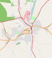
Geographically located in the centre of the Island at 50.701°N, 1.2883°W, Newport is the principal town in the Isle of Wight, to which there are transport connections from all the island's major towns. It is the island's main shopping centre and location for public services. The main A3020 and A3054 roads converge as Medina Way between the busy roundabouts at Coppins Bridge and St Mary's Hospital.
Newport railway station was the hub of the Island's rail network until the mid-20th century, but it closed in 1966 and the site is now occupied by the A3020 Medina Way dual carriageway.
The nearest city to the town is Portsmouth, about 13 miles (21 km) north-east on Portsea Island, adjoining the mainland. More locally, Ryde, the island's largest town, is to the north-east; Sandown and Shanklin are to the east, and Cowes to the north.
The River Medina runs through Newport. North of its confluence with the Lukely Brook at the town's quay it becomes a navigable tidal estuary.
Distance from surrounding settlements
- Cowes – 4.5 miles, 7 km
- East Cowes – 5 miles, 8 km
- Ryde – 7 miles, 11 km
- Shanklin – 9 miles, 15 km
- Sandown – 10 miles, 16 km
- Ventnor – 11 miles, 18 km
- Yarmouth, Isle of Wight – 10 miles, 16 km
Prisons
The town's suburb of Parkhurst is home to two prisons: the notorious Parkhurst Prison and Albany; together they make up HMP Isle of Wight, the largest prison in the UK. Parkhurst and Albany were once among the few top-security prisons in the United Kingdom. Camp Hill was another prison in the area, but closed in 2013.
Amenities
Seaclose Park in Newport, on the east bank of the River Medina, has since 2002 been the location for the revived Isle of Wight Music Festival, held once a year.
Newport is home to the Postal Museum, possibly the largest private collection of vintage postal equipment and post boxes in the world.[8][9]
Newport bus station is the town's central bus terminus and acts as the hub of the Southern Vectis network, with routes from across the Island terminating there.
Sport
St George's Park is the home of Newport Football Club, the most successful of the Island's football teams, currently playing in the Wessex League. The stadium has a capacity of 3,000. The town is also represented by Newport Cricket Club, which plays at Victoria recreational ground. Newport CC have two teams which compete in Harwoods Renault Divisions 1 and 2. The Isle of Wight County Cricket Ground is located at Newclose, on the outskirts of the town.
Schools
The town of Newport and adjoining village of Carisbrooke together have seven primary schools, three secondary schools, a sixth-form campus, a further education college and two special schools. The primary schools located close to the town centre are Newport C of E Primary and Nine Acres Community Primary. Barton Primary is located on Pan estate, whilst Summerfields Primary is nearby on the Staplers estate, both to the east of the town. Hunnyhill Primary is situated on Forest Road to the north of the town, and there are two primary schools in Carisbrooke: Carisbrooke C of E Primary on Wellington Road and St Thomas of Canterbury Catholic Primary in the High Street in the village centre.
The three secondary schools are Carisbrooke College, Medina College and Christ the King College. Carisbrooke College is located on a large site on the outskirts of Carisbrooke village, whilst Christ the King is just down the road occupying two former middle school sites on opposite sides of Wellington Road. Medina College is situated to the east of the town just off of Fairlee Road, along with Medina Leisure Centre and Medina Theatre. The Island Innovation VI Form Campus is the joint sixth form for Carisbrooke and Medina Colleges and is located in the town centre, on the former Nodehill Middle School site.
The Isle of Wight College is located to the north of the town centre, close to St Mary's Roundabout and the large industrial estate. Medina House School is located between Pan and Staplers, and St Georges School is located to the south of the town in the suburban Watergate Road.
Governance
Parliamentary representation
_Crown_Court.jpg)
From the Middle Ages the Parliamentary Borough of Newport had two seats in the House of Commons. Between 1807 and 1811 they were held by two future Prime Ministers: Arthur Wellesley, later to become the Duke of Wellington (who was also elected to two other seats at the same time) and Henry John Temple, 3rd Viscount Palmerston. Palmerston was eligible as an MP because his late father did not convert his Irish peerage into a United Kingdom peerage, which would have confined him to the House of Lords. The local patron arranging the deal was Sir Leonard Holmes, who made it a condition that they never visited the borough.
The borough was also represented by two other future Prime Ministers in the 1820s. George Canning was MP for Newport when appointed Prime Minister in 1827. However, under the law as it then stood, a minister accepting office automatically vacated his seat and had to stand for re-election to the Commons, and Canning chose to stand at Seaford, a government pocket borough in Sussex, rather than fight Newport again. But in the by-election that followed at Newport, the town elected The Hon. William Lamb, later 2nd Viscount Melbourne, whose father had also represented the borough in the 1790s. However, Lamb remained MP for Newport for only two weeks before also being elected for Bletchingley, which he preferred to represent.
Newport's representation in Parliament was cut to one seat in 1867, and it was abolished altogether as a separate constituency in 1885. It now forms part of the Isle of Wight constituency.
Local council
Newport has been under a variety of administrations.
- Until 1974 Newport had its own Newport Borough Council.[10]
- From 1974–1995 Newport was part of Medina Borough Council.[10]
- In 1995 this was abolished and the Isle of Wight Council took over responsibility. Newport remained unparished until 2008, when the Isle of Wight Council Unitary Authority was created.[10]
- Newport Town Management Committee was established in April 2006 by the Isle of Wight Council as an interim body for the town until the Government gave approval for a parish or town council. The Management Committee had no formal powers and was technically no more than an advisory committee to the Isle of Wight Council. However it was treated as a transitional authority, which acted in many ways as a town or parish council.[11]
- The first election for Newport Parish Council occurred on 1 May 2008.[11]
Notable people
In birth order:
- Elizabeth Stuart (1635–1650), daughter of Charles I and Henrietta Maria, is buried at St. Thomas' Church.
- Edward Vernon Utterson (1775–1856), lawyer, one of Six Clerks in Chancery, antiquary and editor
- Charlotte Anley (1796–1893), novelist and songwriter, lived in the town in the mid–1820s.
- Maxwell Gray (Mary Gleed Tuttiett; 1846–1923), writer
- Westmore Family, prominent family in Hollywood make-up
- Craig Douglas (born 1941), pop singer of the late 1950s and early 1960s
- Geoffrey Hughes (1944–2012), actor
- Tony Howe (born 1947), club steward.
- Anthony Minghella (1954–2008), film director
- Phill Jupitus (born 1962), comedian
- Kelly Sotherton (born 1976), heptathlete
- Darren Mew (born 1979), breast-stroke swimmer
- Lewis Buxton (born 1983), footballer (Bolton Wanderers)
- Gary Silk (born 1984), footballer
- David Griffiths (born 1985), cricketer
- Chris Russell (born 1989), cricketer
- Danny Briggs (born 1991), cricketer
See also
Notes
- ↑ Office of National Statistics: QS102EW - Population density retrieved 30 May 2017
- ↑ "Town population 2011". Retrieved 18 October 2011.
- ↑ M. L. Shackley: A Contextual Study of the Mousterian Industry at Great Pan Farm..., Proceedings of the Isle of Wight Natural History and Archaeological Society, 6:8, pp. 524 ff.
- ↑ The villa on public display was found in 1926. Excavations at the site demonstrate that the villa was built around AD 280. The villa featured underfloor heating, elaborate hot and cold baths, sauna and massage rooms and a large kitchen.
- ↑ BRANNON'S PICTURE OF THE ISLE OF WIGHT; Or The Expeditious Traveller's Index to Its Prominent Beauties & Objects of Interest. Compiled Especially with Reference to Those Numerous Visitors Who Can Spare but Two or Three Days to Make the Tour of the Island, Printed and Published by George Brannon, Wootton, Isle of Wight, 1843 (various sources give dates of 1844, 1848, 1849, etc, possibly of other editions)
- ↑ "Newport". Retrieved 3 September 2017.
- ↑ "Queen Victoria memorial". Memorials & Monuments on the Isle of Wight. 24 July 2009. Retrieved 20 November 2009.
- ↑ "Home". www.postalmuseum.co.uk.
- ↑ Isle of Wight Postal Museum Archived 18 September 2008 at the Wayback Machine., WightCAM – photographically illustrated walks on the Isle of Wight.
- 1 2 3 "IW County Record Office local government records". Archived from the original on 29 August 2008.
- 1 2 "Newport Parish Council Homepage". www.iwight.gov.uk. Archived from the original on 19 October 2008. Retrieved 25 August 2008.
External links
| Wikimedia Commons has media related to: |
Isle of Wight Portal | |
| Unitary authorities | |
| Major settlements | |
| Rivers | |
| Topics | |