New Hampshire Route 13
| ||||
|---|---|---|---|---|
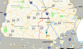 Map of southern New Hampshire with NH 13 highlighted in red | ||||
| Route information | ||||
| Maintained by NHDOT | ||||
| Length | 43.368 mi[1] (69.794 km) | |||
| Major junctions | ||||
| South end |
| |||
|
| ||||
| North end |
| |||
| Location | ||||
| Counties | Hillsborough, Merrimack | |||
| Highway system | ||||
| ||||

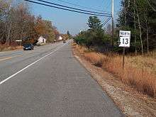
NH 13 northbound entering Concord
New Hampshire Route 13 is a 43.38-mile (69.81 km) long north–south state highway in the state of New Hampshire, United States. The highway runs from Brookline to Concord.
The southern terminus is at the Massachusetts state line in Brookline, where the route continues south as Massachusetts Route 13. The northern terminus is in the center of Concord at U.S. Route 202 and New Hampshire Route 9, locally the intersection of South Street and Pleasant Street.
Junction list
| County | Location[1][2] | mi[1][2] | km | Destinations | Notes |
|---|---|---|---|---|---|
| Hillsborough | Brookline | 0.000 | 0.000 | Continuation from Massachusetts | |
| 3.385 | 5.448 | Western terminus of NH 130 | |||
| Milford | 8.391– 8.550 | 13.504– 13.760 | Interchange | ||
| 9.760 | 15.707 | Union Square (the "Milford Oval") | |||
| New Boston | 20.572 | 33.107 | Eastern terminus of NH 136 | ||
| Goffstown | 27.135 | 43.670 | Southern end of concurrency with NH 114 | ||
| 27.454 | 44.183 | Northern end of concurrency with NH 114 | |||
| Merrimack | Dunbarton | 37.072 | 59.662 | Northern terminus of NH 77 | |
| Concord | 40.889– 41.172 | 65.804– 66.260 | Exit 2 on I-89 | ||
| 43.368 | 69.794 | Northern terminus of NH 13 | |||
1.000 mi = 1.609 km; 1.000 km = 0.621 mi
| |||||
References
- 1 2 3 Bureau of Planning & Community Assistance (February 20, 2015). "NH Public Roads". Concord, New Hampshire: New Hampshire Department of Transportation. Retrieved April 7, 2015.
- 1 2 Bureau of Planning & Community Assistance (April 3, 2015). "Nodal Reference 2015, State of New Hampshire". New Hampshire Department of Transportation. Retrieved April 7, 2015.
External links
This article is issued from
Wikipedia.
The text is licensed under Creative Commons - Attribution - Sharealike.
Additional terms may apply for the media files.