Nedre Eiker
| Nedre Eiker kommune | |||
|---|---|---|---|
| Municipality | |||
 | |||
| |||
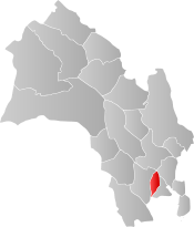 Nedre Eiker within Buskerud | |||
| Coordinates: 59°45′53″N 10°2′0″E / 59.76472°N 10.03333°ECoordinates: 59°45′53″N 10°2′0″E / 59.76472°N 10.03333°E | |||
| Country | Norway | ||
| County | Buskerud | ||
| District | Eiker, Lower Buskerud | ||
| Administrative centre | Mjøndalen | ||
| Government | |||
| • Mayor (2007) | Elly Therese Thoresen (H) | ||
| Area | |||
| • Total | 122 km2 (47 sq mi) | ||
| • Land | 114 km2 (44 sq mi) | ||
| Area rank | #369 in Norway | ||
| Population (2004) | |||
| • Total | 21,377 | ||
| • Rank | #42 in Norway | ||
| • Density | 187/km2 (480/sq mi) | ||
| • Change (10 years) | 11.5% | ||
| Demonym(s) | Eikværing[1] | ||
| Time zone | UTC+01:00 (CET) | ||
| • Summer (DST) | UTC+02:00 (CEST) | ||
| ISO 3166 code | NO-0625 | ||
| Official language form | Bokmål | ||
| Website |
www | ||


Nedre Eiker is a municipality in Buskerud county, Norway. It is part of the traditional region of Eiker. The administrative centre of the municipality is the village of Mjøndalen. The old municipality of Eiker was divided into Nedre Eiker (lower Eiker) and Øvre Eiker (upper) on 1 July 1885.
General information
Name
The Old Norse form of the name was Eikjar. The name is the plural form of eiki which means "oak wood". The meaning of Nedre Eiker is "(the) lower (part of) Eiker". (The municipality of Eiker was divided in 1885.)
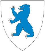
Coat-of-arms
The coat-of-arms was granted on 26 June 1970. The arms show three gold-colored oak leaves on a red background. The arms are canting because the meaning of the name (Eik) comes from the word for oak.[2]
(See also coat-of-arms of Eigersund, Songdalen, Tingvoll and Øvre Eiker)
| Ancestry | Number |
|---|---|
| 768 | |
| 488 | |
| 410 | |
| 290 | |
| 239 | |
| 230 | |
| 198 | |
| 170 | |
| 143 | |
| 136 |
Geography
.jpg)

The municipality is located in the southern part of Buskerud county. It borders the municipalities of Lier, Drammen, Hof, and Øvre Eiker. The majority of the residents live in the villages of Mjøndalen, Krokstadelva, Solbergelva, and Steinberg.
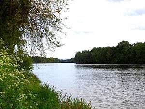
The Drammenselva river flows through the municipality of Nedre Eiker. It is one of the largest rivers in Norway, with a course running from Tyrifjorden in the north to Drammensfjord in the south.
Churches in Nedre Eiker
Notable residents
- Lars Korvald, former Prime Minister of Norway
- Herman Wildenvey (1886–1959), poet and author
- Svein Johannessen (1937–2007), international master of chess
- Jørn Hurum (b. 1967), paleontologist
- Ragnar Christiansen (born 1922), former Minister and Member of Parliament
Sister cities
References
- ↑ "Navn på steder og personer: Innbyggjarnamn" (in Norwegian). Språkrådet. Retrieved 2015-12-01.
- ↑ Norske Kommunevåpen (1990). "Nye kommunevåbener i Norden". Retrieved 2009-01-10.
- ↑ "Immigrants and Norwegian-born to immigrant parents". ssb.no. Archived from the original on 2 July 2015. Retrieved 30 July 2017.
- ↑ "Mjøndalen kirke". lokalhistoriewiki.no. Retrieved December 1, 2017.
- ↑ Sigrid Marie Christie, Håkon Christie. "Nedre Eiker kirke". Norges Kirker. Retrieved December 1, 2017.
- ↑ "Solberg kapell". Norske Kirkebygg. Retrieved December 1, 2017.
- ↑ "Tabor kapell". Norske Kirkebygg. Retrieved December 1, 2017.
- ↑ "Vennskaps- og samarbeidsavtale" (in Norwegian). Nedre Eiker kommune. Archived from the original on 2009-08-29. Retrieved 2009-01-10.
External links
| Wikimedia Commons has media related to Nedre Eiker. |
| Look up Nedre Eiker in Wiktionary, the free dictionary. |
- Municipal fact sheet from Statistics Norway

- Culture in Nedre Eiker on the map from Kulturnett.no