Lier, Norway
| Lier kommune | |||
|---|---|---|---|
| Municipality | |||
 City Hall in Lierbyen | |||
| |||
 Lier within Buskerud | |||
| Coordinates: 59°47′38″N 10°15′58″E / 59.7937863°N 10.2660000°ECoordinates: 59°47′38″N 10°15′58″E / 59.7937863°N 10.2660000°E | |||
| Country | Norway | ||
| County | Buskerud | ||
| District | Lower Buskerud | ||
| Administrative centre | Lierbyen | ||
| Government | |||
| • Mayor (2011) | Helene Justad (H) | ||
| Area | |||
| • Total | 301 km2 (116 sq mi) | ||
| • Land | 281 km2 (108 sq mi) | ||
| Area rank | #277 in Norway | ||
| Population (24971) | |||
| • Total | 21,594 | ||
| • Rank | #40 in Norway | ||
| • Density | 77/km2 (200/sq mi) | ||
| • Change (10 years) | 9.8% | ||
| Demonym(s) | Liung[1] | ||
| Time zone | UTC+01:00 (CET) | ||
| • Summer (DST) | UTC+02:00 (CEST) | ||
| ISO 3166 code | NO-0626 | ||
| Official language form | Bokmål | ||
| Website |
www | ||

Lier is a municipality in Buskerud county, Norway. The administrative centre of the municipality is the village of Lierbyen. The municipality of Lier was established on 1 January 1838 (see formannskapsdistrikt). The area Åssiden was transferred from Lier to the neighboring municipality of Drammen on 1 July 1951.
Norway's longest indoor shopping center, Liertoppen, is located in Lierskogen. The newspaper Lierposten is published in Lier.[2]
General information
Name
The Old Norse form of the name was Líðir. The name is the plural form of líð which means "hillside".
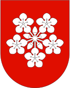
Coat-of-arms
The coat-of-arms is from modern times and was designed by Hallvard Trætteberg. They were granted on 14 August 1970. The arms show five silver-colored apple blossoms on a red background. The area is well known for the production of various types of fruit, berries, vegetables, and flowers, so this was chosen as a symbol of the area's lush scenery and agriculture.[3][4]
| Ancestry | Number |
|---|---|
| 1,199 | |
| 343 | |
| 310 | |
| 301 | |
| 245 | |
| 197 | |
| 186 | |
| 166 | |
| 162 | |
| 153 |
Geography
Lier borders to the municipalities of Asker and Bærum (in Akershus county) and Drammen, Modum, Nedre Eiker, Røyken and Hole (in Buskerud county). It includes the villages of Lierbyen, Sylling, Sjåstad, Nøste, Gullaug, Lierskogen, and Tranby.
Lier is thought of as a "green lung" for Norway's capital, Oslo, with its vast number of fields and apple trees. It is also famous for its agricultural products as strawberries and vegetables.
The Gilhusodden Nature Preserve is home of many different bird species. The area is also used for recreation, especially swimming and sunbathing, with its long, shallow beach.
Notable residents
- Sæbjørn Buttedahl, actor and sculptor
- Bjørn Eidsvåg, artist and preacher, born in Sauda
- Karin Fossum, author, living in Sylling/Lier
- Thorleif Haug (1894–1934), skier/ski jumper
- Hans Christian Heg, American Civil War officer
- Thorbjørn Jagland, politician, former prime minister,currently Secretary General of the Council of Europe
- Martin Kolberg, secretary of The Norwegian Labour Party
- Gert Nygårdshaug, author
- Sten Stensen, speed skater
- Hallvard Vebjørnsson or St. Hallvard, Oslo's patron saint, was born in Lier
- Ole Ivar Lovaas, pioneering behaviorist, was born in Lier.
Attractions
_20080608-4.jpg)

- Bygdeborgen – village stronghold from the Middle Ages on Fosskollen
- Frogner Kirke – romanesque parish church built in 1650
- Gilhusodden – Nature Preserve
- Gjellebekk skanse – defence bulwark during the Great Northern War which prevented a Swedish invasion of Norway in 1716
- Lier Bygdetun – Rural Museum including a 40-acre (160,000 m2) farm
- Hans Christian Heg statue - at Haugestad in the community of Lierbyen
- St. Hallvard's minne – memorial of St. Hallvard, patron saint of Oslo
- Sylling cemetery – Ten British RAF Airmen are buried in the Commonwealth War Graves Plot
Sister cities
The following cities are twinned with Lier:[6]
Gallery
 Liertoppen Shopping Center
 Gamle Hegg skole
 Jacobsen Elektro main office
.jpg) Hvalsdammen
Hvalsdammen
References
- ↑ "Navn på steder og personer: Innbyggjarnamn" (in Norwegian). Språkrådet. Retrieved 2015-12-01.
- ↑ Store norske leksikon: Lierposten.
- ↑ Norske Kommunevåpen (1990). "Nye kommunevåbener i Norden". Retrieved 2009-01-10.
- ↑ "Liers kommunevåpen" (in Norwegian). Lier kommune. Archived from the original on 24 July 2011. Retrieved 2009-01-10.
- ↑ "Immigrants and Norwegian-born to immigrant parents". ssb.no. Archived from the original on 30 July 2017. Retrieved 30 July 2017.
- ↑ "Vennskapskommuner" (in Norwegian). Lier kommune. Archived from the original on 24 July 2011. Retrieved 2009-01-10.
External links
| Wikimedia Commons has media related to Lier, Buskerud. |
| Look up Lier in Wiktionary, the free dictionary. |
- Municipal fact sheet from Statistics Norway

- Lier Bygdetun
- Lier Historielag
- Sylling churchyard