Necha Salyan Gaupalika
| Necha-Salyan Gaupalika नेचा-सल्यान गाउँपालिका | |
|---|---|
| Gaupalika | |
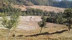 Salyan Fedi ricefield and Dyamde ricefield | |
 Necha-Salyan Gaupalika Necha Salyan Gaupalika in Province No. 1  Necha-Salyan Gaupalika Necha-Salyan Gaupalika (Nepal) | |
| Coordinates: 27°21′36″N 86°39′36″E / 27.3600°N 86.6600°ECoordinates: 27°21′36″N 86°39′36″E / 27.3600°N 86.6600°E | |
| country | Nepal |
| Province | Province No. 1 |
| District | Solukhumbu District |
| established | 27 Falgun 2073 |
| Area | |
| • Total | 94.49 km2 (36.48 sq mi) |
| Population (2017)[1] | |
| • Total | 16,129 |
| • Density | 170/km2 (440/sq mi) |
| Time zone | UTC+5:45 (Nepal Standard Time) |
| Area code(s) | +977-038 |
| Office | Present Necha Bedghari VDC Office |
Necha Salyan Gaupalika (Nepali: ne:नेचासल्यान गाउँपालिका) is a Gaupalika (rural municipality) located at Solukhumbu district.[1][2]
Tingla, Salyan, Necha Bedghari and Necha Batase VDCs were incorporated into Necha Salyan Gaupalika. This rural municipality has a population of 16,129 and an area of 94.49 square kilometres (36.48 sq mi). The current VDC Office of Necha Bedghari is the office of this Gaupalika.[2]
References
- 1 2 "List of Urban and Rural Municipalities of Nepal" (PDF). Ministry of Federal Affairs and Local Development. Retrieved 2017-06-02.
- 1 2 "हेर्नुहोस्, तपाईं कुन गाउँपालिका वा नगरपालिकामा पर्नुभयो?". setopati. Retrieved Falgun 2073. Check date values in:
|accessdate=(help)
This article is issued from
Wikipedia.
The text is licensed under Creative Commons - Attribution - Sharealike.
Additional terms may apply for the media files.